You are here: Home > Network List > US - United States National Seismic Network Stations List
> Station BRAL Brewton, Alabama, USA > Earthquake Result Viewer
BRAL Brewton, Alabama, USA - Earthquake Result Viewer
*The percent match for this event was below the threshold and hence no stack was calculated.
| Earthquake location: |
Samoa Islands Region |
| Earthquake latitude/longitude: |
-16.2/-173.0 |
| Earthquake time(UTC): |
2009/09/29 (272) 18:21:42 GMT |
| Earthquake Depth: |
10 km |
| Earthquake Magnitude: |
5.8 MB |
| Earthquake Catalog/Contributor: |
WHDF/NEIC |
|
| Network: |
US United States National Seismic Network |
| Station: |
BRAL Brewton, Alabama, USA |
| Lat/Lon: |
31.01 N/87.06 W |
| Elevation: |
61 m |
|
| Distance: |
94.8 deg |
| Az: |
59.25 deg |
| Baz: |
254.088 deg |
| Ray Param: |
$rayparam |
*The percent match for this event was below the threshold and hence was not used in the summary stack. |
|
| Radial Match: |
93.275856 % |
| Radial Bump: |
189 |
| Transverse Match: |
75.03845 % |
| Transverse Bump: |
306 |
| SOD ConfigId: |
2622 |
| Insert Time: |
2010-03-05 02:58:05.221 +0000 |
| GWidth: |
2.5 |
| Max Bumps: |
400 |
| Tol: |
0.001 |
|
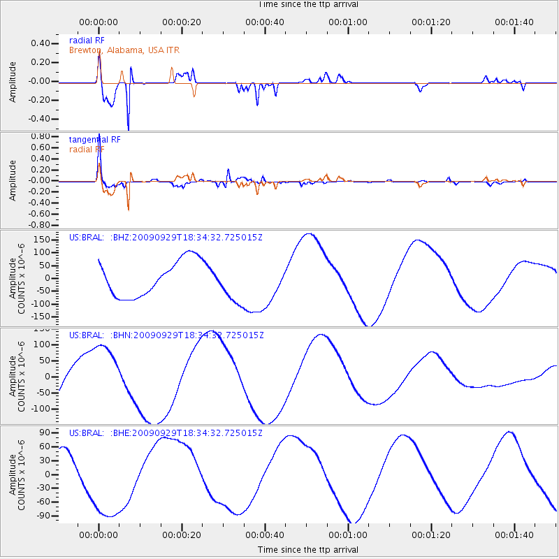
Signal To Noise
| Channel | StoN | STA | LTA |
| US:BRAL: :BHN:20090929T18:34:32.725015Z | 0.7002667 | 6.758236E-5 | 9.650946E-5 |
| US:BRAL: :BHE:20090929T18:34:32.725015Z | 1.798627 | 9.34041E-5 | 5.1930776E-5 |
| US:BRAL: :BHZ:20090929T18:34:32.725015Z | 1.0961926 | 7.53689E-5 | 6.875516E-5 |
| Arrivals |
| Ps | |
| PpPs | |
| PsPs/PpSs | |


