You are here: Home > Network List > TA - USArray Transportable Network (new EarthScope stations) Stations List
> Station C06D Leavenworth, WQ, USA > Earthquake Result Viewer
C06D Leavenworth, WQ, USA - Earthquake Result Viewer

| Earthquake location: |
Oaxaca, Mexico |
| Earthquake latitude/longitude: |
16.6/-97.7 |
| Earthquake time(UTC): |
2016/05/08 (129) 07:34:02 GMT |
| Earthquake Depth: |
24 km |
| Earthquake Magnitude: |
5.9 MB |
| Earthquake Catalog/Contributor: |
NEIC PDE/NEIC ALERT |
|
| Network: |
TA USArray Transportable Network (new EarthScope stations) |
| Station: |
C06D Leavenworth, WQ, USA |
| Lat/Lon: |
47.92 N/120.89 W |
| Elevation: |
544 m |
|
| Distance: |
36.6 deg |
| Az: |
333.628 deg |
| Baz: |
140.704 deg |
| Ray Param: |
0.07654367 |
| Estimated Moho Depth: |
13.25 km |
| Estimated Crust Vp/Vs: |
1.77 |
| Assumed Crust Vp: |
6.597 km/s |
| Estimated Crust Vs: |
3.733 km/s |
| Estimated Crust Poisson's Ratio: |
0.26 |
|
| Radial Match: |
81.83019 % |
| Radial Bump: |
400 |
| Transverse Match: |
75.65305 % |
| Transverse Bump: |
400 |
| SOD ConfigId: |
7422571 |
| Insert Time: |
2019-04-22 13:25:08.101 +0000 |
| GWidth: |
2.5 |
| Max Bumps: |
400 |
| Tol: |
0.001 |
|
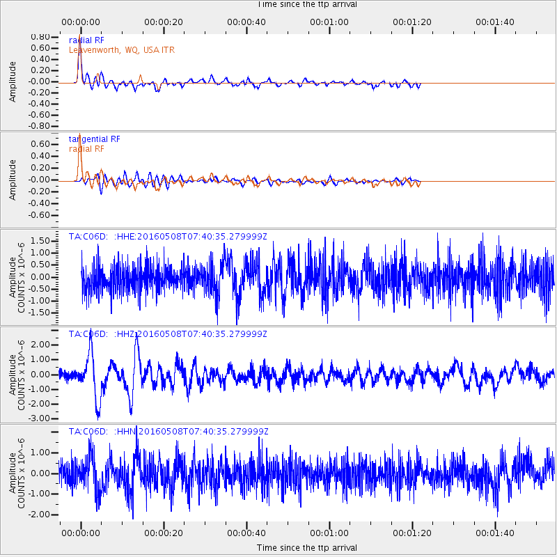
Signal To Noise
| Channel | StoN | STA | LTA |
| TA:C06D: :HHZ:20160508T07:40:35.279999Z | 5.555635 | 1.5609025E-6 | 2.8095843E-7 |
| TA:C06D: :HHN:20160508T07:40:35.279999Z | 1.6008177 | 8.2528896E-7 | 5.155421E-7 |
| TA:C06D: :HHE:20160508T07:40:35.279999Z | 1.3687416 | 6.614966E-7 | 4.8328815E-7 |
| Arrivals |
| Ps | 1.7 SECOND |
| PpPs | 5.1 SECOND |
| PsPs/PpSs | 6.8 SECOND |


