You are here: Home > Network List > IU - Global Seismograph Network (GSN - IRIS/USGS) Stations List
> Station XMAS Kiritimati Island, Republic of Kiribati > Earthquake Result Viewer
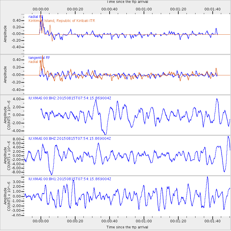
XMAS Kiritimati Island, Republic of Kiribati - Earthquake Result Viewer
*The percent match for this event was below the threshold and hence no stack was calculated.
| Earthquake location: |
Solomon Islands |
| Earthquake latitude/longitude: |
-10.9/163.9 |
| Earthquake time(UTC): |
2015/08/15 (227) 07:47:06 GMT |
| Earthquake Depth: |
6.4 km |
| Earthquake Magnitude: |
6.6 MWP, 6.6 MI |
| Earthquake Catalog/Contributor: |
NEIC PDE/NEIC COMCAT |
|
| Network: |
IU Global Seismograph Network (GSN - IRIS/USGS) |
| Station: |
XMAS Kiritimati Island, Republic of Kiribati |
| Lat/Lon: |
2.04 N/157.45 W |
| Elevation: |
20 m |
|
| Distance: |
40.6 deg |
| Az: |
73.8 deg |
| Baz: |
250.695 deg |
| Ray Param: |
$rayparam |
*The percent match for this event was below the threshold and hence was not used in the summary stack. |
|
| Radial Match: |
79.4782 % |
| Radial Bump: |
398 |
| Transverse Match: |
46.47455 % |
| Transverse Bump: |
400 |
| SOD ConfigId: |
1085051 |
| Insert Time: |
2015-08-29 08:01:14.470 +0000 |
| GWidth: |
2.5 |
| Max Bumps: |
400 |
| Tol: |
0.001 |
|
Signal To Noise
| Channel | StoN | STA | LTA |
| IU:XMAS:00:BHZ:20150815T07:54:15.869004Z | 2.1768727 | 2.7706205E-6 | 1.2727527E-6 |
| IU:XMAS:00:BH1:20150815T07:54:15.869004Z | 1.6137484 | 1.2014486E-6 | 7.4450804E-7 |
| IU:XMAS:00:BH2:20150815T07:54:15.869004Z | 2.8180368 | 1.8399489E-6 | 6.529187E-7 |
| Arrivals |
| Ps | |
| PpPs | |
| PsPs/PpSs | |


