You are here: Home > Network List > TA - USArray Transportable Network (new EarthScope stations) Stations List
> Station H23K Yukon River, AK, USA > Earthquake Result Viewer
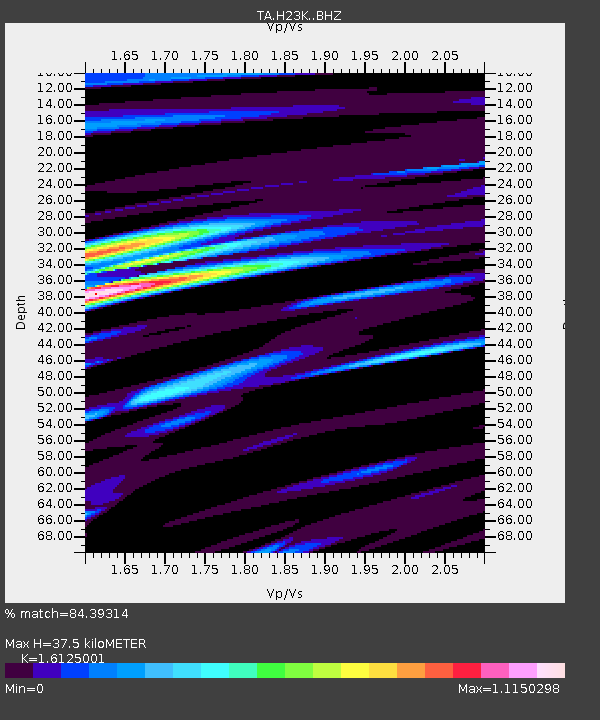
H23K Yukon River, AK, USA - Earthquake Result Viewer
| Earthquake location: |
Oaxaca, Mexico |
| Earthquake latitude/longitude: |
16.6/-97.7 |
| Earthquake time(UTC): |
2016/05/08 (129) 07:34:02 GMT |
| Earthquake Depth: |
24 km |
| Earthquake Magnitude: |
5.9 MB |
| Earthquake Catalog/Contributor: |
NEIC PDE/NEIC ALERT |
|
| Network: |
TA USArray Transportable Network (new EarthScope stations) |
| Station: |
H23K Yukon River, AK, USA |
| Lat/Lon: |
65.83 N/149.54 W |
| Elevation: |
617 m |
|
| Distance: |
59.9 deg |
| Az: |
338.006 deg |
| Baz: |
119.295 deg |
| Ray Param: |
0.061882146 |
| Estimated Moho Depth: |
37.5 km |
| Estimated Crust Vp/Vs: |
1.61 |
| Assumed Crust Vp: |
6.566 km/s |
| Estimated Crust Vs: |
4.072 km/s |
| Estimated Crust Poisson's Ratio: |
0.19 |
|
| Radial Match: |
84.39314 % |
| Radial Bump: |
400 |
| Transverse Match: |
72.63121 % |
| Transverse Bump: |
400 |
| SOD ConfigId: |
7422571 |
| Insert Time: |
2019-04-22 13:25:18.621 +0000 |
| GWidth: |
2.5 |
| Max Bumps: |
400 |
| Tol: |
0.001 |
|

Signal To Noise
| Channel | StoN | STA | LTA |
| TA:H23K: :BHZ:20160508T07:43:34.150024Z | 6.467236 | 8.1794E-7 | 1.2647443E-7 |
| TA:H23K: :BHN:20160508T07:43:34.150024Z | 1.952787 | 2.0843189E-7 | 1.0673559E-7 |
| TA:H23K: :BHE:20160508T07:43:34.150024Z | 3.3298252 | 3.7849125E-7 | 1.13667E-7 |
| Arrivals |
| Ps | 3.7 SECOND |
| PpPs | 14 SECOND |
| PsPs/PpSs | 18 SECOND |


