You are here: Home > Network List > TA - USArray Transportable Network (new EarthScope stations) Stations List
> Station L04D Klamath Falls, OR, USA > Earthquake Result Viewer
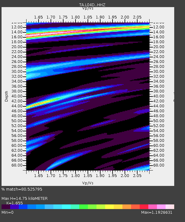
L04D Klamath Falls, OR, USA - Earthquake Result Viewer
| Earthquake location: |
Oaxaca, Mexico |
| Earthquake latitude/longitude: |
16.6/-97.7 |
| Earthquake time(UTC): |
2016/05/08 (129) 07:34:02 GMT |
| Earthquake Depth: |
24 km |
| Earthquake Magnitude: |
5.9 MB |
| Earthquake Catalog/Contributor: |
NEIC PDE/NEIC ALERT |
|
| Network: |
TA USArray Transportable Network (new EarthScope stations) |
| Station: |
L04D Klamath Falls, OR, USA |
| Lat/Lon: |
42.22 N/122.30 W |
| Elevation: |
1437 m |
|
| Distance: |
33.1 deg |
| Az: |
325.53 deg |
| Baz: |
133.057 deg |
| Ray Param: |
0.078315705 |
| Estimated Moho Depth: |
14.75 km |
| Estimated Crust Vp/Vs: |
1.65 |
| Assumed Crust Vp: |
6.522 km/s |
| Estimated Crust Vs: |
3.941 km/s |
| Estimated Crust Poisson's Ratio: |
0.21 |
|
| Radial Match: |
80.525795 % |
| Radial Bump: |
400 |
| Transverse Match: |
59.110714 % |
| Transverse Bump: |
400 |
| SOD ConfigId: |
7422571 |
| Insert Time: |
2019-04-22 13:25:33.147 +0000 |
| GWidth: |
2.5 |
| Max Bumps: |
400 |
| Tol: |
0.001 |
|

Signal To Noise
| Channel | StoN | STA | LTA |
| TA:L04D: :HHZ:20160508T07:40:05.029999Z | 3.6759698 | 1.0091561E-6 | 2.7452785E-7 |
| TA:L04D: :HHN:20160508T07:40:05.029999Z | 0.7588471 | 3.195784E-7 | 4.2113672E-7 |
| TA:L04D: :HHE:20160508T07:40:05.029999Z | 1.2784578 | 4.74116E-7 | 3.7084993E-7 |
| Arrivals |
| Ps | 1.6 SECOND |
| PpPs | 5.5 SECOND |
| PsPs/PpSs | 7.1 SECOND |


