You are here: Home > Network List > UW - Pacific Northwest Regional Seismic Network Stations List
> Station MRBL Marblemount, WA, USA > Earthquake Result Viewer
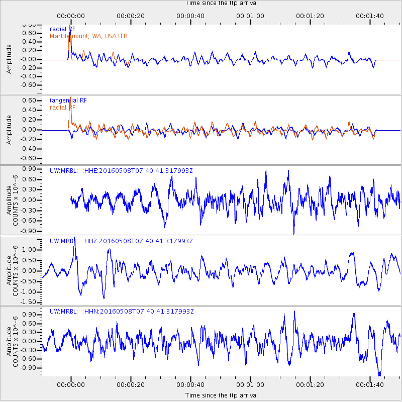
MRBL Marblemount, WA, USA - Earthquake Result Viewer
*The percent match for this event was below the threshold and hence no stack was calculated.
| Earthquake location: |
Oaxaca, Mexico |
| Earthquake latitude/longitude: |
16.6/-97.7 |
| Earthquake time(UTC): |
2016/05/08 (129) 07:34:02 GMT |
| Earthquake Depth: |
24 km |
| Earthquake Magnitude: |
5.9 MB |
| Earthquake Catalog/Contributor: |
NEIC PDE/NEIC ALERT |
|
| Network: |
UW Pacific Northwest Regional Seismic Network |
| Station: |
MRBL Marblemount, WA, USA |
| Lat/Lon: |
48.52 N/121.48 W |
| Elevation: |
75 m |
|
| Distance: |
37.3 deg |
| Az: |
333.751 deg |
| Baz: |
140.364 deg |
| Ray Param: |
$rayparam |
*The percent match for this event was below the threshold and hence was not used in the summary stack. |
|
| Radial Match: |
76.791176 % |
| Radial Bump: |
400 |
| Transverse Match: |
49.73784 % |
| Transverse Bump: |
400 |
| SOD ConfigId: |
7422571 |
| Insert Time: |
2019-04-22 13:26:19.350 +0000 |
| GWidth: |
2.5 |
| Max Bumps: |
400 |
| Tol: |
0.001 |
|
Signal To Noise
| Channel | StoN | STA | LTA |
| UW:MRBL: :HHZ:20160508T07:40:41.317993Z | 3.7493014 | 7.546131E-7 | 2.0126765E-7 |
| UW:MRBL: :HHN:20160508T07:40:41.317993Z | 0.9500399 | 1.8548813E-7 | 1.9524246E-7 |
| UW:MRBL: :HHE:20160508T07:40:41.317993Z | 2.5044684 | 4.1564047E-7 | 1.6595956E-7 |
| Arrivals |
| Ps | |
| PpPs | |
| PsPs/PpSs | |


