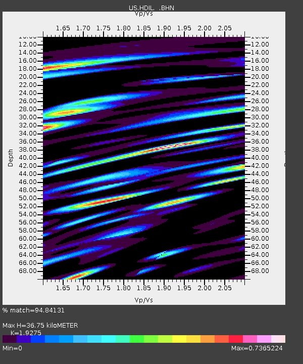
HDIL Hopedale, Illinois, USA - Earthquake Result Viewer
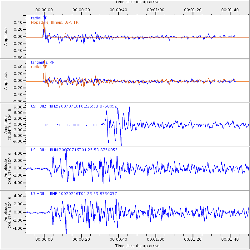
Earthquake location: Near West Coast Of Honshu, Japan
Earthquake latitude/longitude: 37.5/138.4
Earthquake time(UTC): 2007/07/16 (197) 01:13:22 GMT
Earthquake Depth: 12 km
Earthquake Magnitude: 6.5 MB, 6.4 MS, 6.6 MW, 6.5 MW
Earthquake Catalog/Contributor: WHDF/NEIC
Network: US United States National Seismic Network
Station: HDIL Hopedale, Illinois, USA
Lat/Lon: 40.56 N/89.29 W
Elevation: 219 m
Distance: 90.8 deg
Az: 34.33 deg
Baz: 323.956 deg
Ray Param: 0.041645426
Estimated Moho Depth: 36.75 km
Estimated Crust Vp/Vs: 1.93
Assumed Crust Vp: 6.498 km/s
Estimated Crust Vs: 3.371 km/s
Estimated Crust Poisson's Ratio: 0.32
Radial Match: 94.84131 %
Radial Bump: 400
Transverse Match: 89.24258 %
Transverse Bump: 400
SOD ConfigId: 2564
Insert Time: 2010-03-05 02:58:47.325 +0000
GWidth: 2.5
Max Bumps: 400
Tol: 0.001

Signal To Noise

ChannelStoNSTALTA
US:HDIL: :BHN:20070716T01:25:53.875005Z10.4918391.062076E-61.0122877E-7
US:HDIL: :BHE:20070716T01:25:53.875005Z10.4248258.944039E-78.5795584E-8
US:HDIL: :BHZ:20070716T01:25:53.875005Z42.9895063.5201742E-68.18845E-8
Arrivals
Ps5.3 SECOND
PpPs16 SECOND
PsPs/PpSs22 SECOND