You are here: Home > Network List > IW - Intermountain West Stations List
> Station RWWY Rawlins, Wyoming, USA > Earthquake Result Viewer
RWWY Rawlins, Wyoming, USA - Earthquake Result Viewer
| Earthquake location: |
Solomon Islands |
| Earthquake latitude/longitude: |
-10.9/163.9 |
| Earthquake time(UTC): |
2015/08/15 (227) 07:47:06 GMT |
| Earthquake Depth: |
6.4 km |
| Earthquake Magnitude: |
6.6 MWP, 6.6 MI |
| Earthquake Catalog/Contributor: |
NEIC PDE/NEIC COMCAT |
|
| Network: |
IW Intermountain West |
| Station: |
RWWY Rawlins, Wyoming, USA |
| Lat/Lon: |
41.69 N/107.21 W |
| Elevation: |
2402 m |
|
| Distance: |
96.3 deg |
| Az: |
48.892 deg |
| Baz: |
261.138 deg |
| Ray Param: |
0.040542528 |
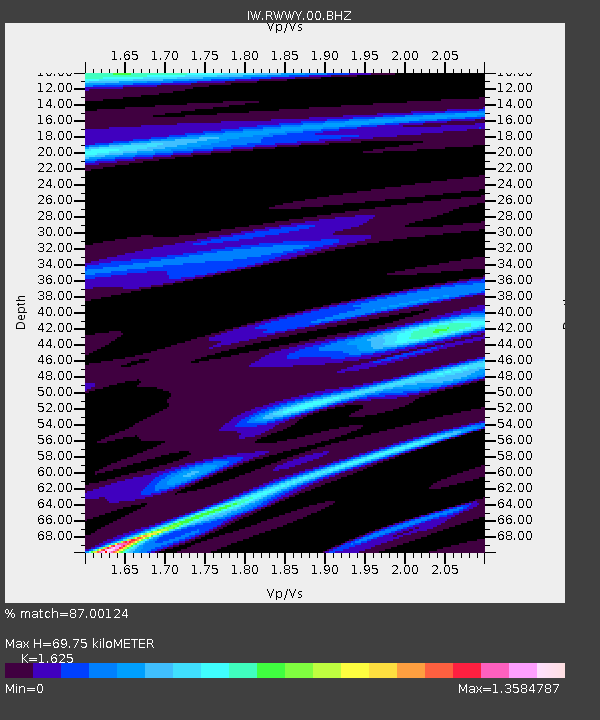
| Estimated Moho Depth: |
69.75 km |
| Estimated Crust Vp/Vs: |
1.62 |
| Assumed Crust Vp: |
6.159 km/s |
| Estimated Crust Vs: |
3.79 km/s |
| Estimated Crust Poisson's Ratio: |
0.20 |
|
| Radial Match: |
87.00124 % |
| Radial Bump: |
393 |
| Transverse Match: |
60.252304 % |
| Transverse Bump: |
400 |
| SOD ConfigId: |
1085051 |
| Insert Time: |
2015-08-29 08:01:57.622 +0000 |
| GWidth: |
2.5 |
| Max Bumps: |
400 |
| Tol: |
0.001 |
|

Signal To Noise
| Channel | StoN | STA | LTA |
| IW:RWWY:00:BHZ:20150815T08:00:04.338975Z | 6.6968946 | 3.158444E-7 | 4.7162814E-8 |
| IW:RWWY:00:BH1:20150815T08:00:04.338975Z | 0.6162505 | 3.998283E-8 | 6.488081E-8 |
| IW:RWWY:00:BH2:20150815T08:00:04.338975Z | 4.039475 | 1.5947876E-7 | 3.9480067E-8 |
| Arrivals |
| Ps | 7.2 SECOND |
| PpPs | 29 SECOND |
| PsPs/PpSs | 36 SECOND |


