You are here: Home > Network List > US - United States National Seismic Network Stations List
> Station HDIL Hopedale, Illinois, USA > Earthquake Result Viewer
HDIL Hopedale, Illinois, USA - Earthquake Result Viewer

| Earthquake location: |
Northern Mid-Atlantic Ridge |
| Earthquake latitude/longitude: |
52.4/-31.8 |
| Earthquake time(UTC): |
2007/05/23 (143) 04:41:46 GMT |
| Earthquake Depth: |
10 km |
| Earthquake Magnitude: |
5.6 MS, 5.4 MB, 5.7 MW, 5.6 MW |
| Earthquake Catalog/Contributor: |
WHDF/NEIC |
|
| Network: |
US United States National Seismic Network |
| Station: |
HDIL Hopedale, Illinois, USA |
| Lat/Lon: |
40.56 N/89.29 W |
| Elevation: |
219 m |
|
| Distance: |
40.3 deg |
| Az: |
276.55 deg |
| Baz: |
53.11 deg |
| Ray Param: |
0.074481174 |
| Estimated Moho Depth: |
41.5 km |
| Estimated Crust Vp/Vs: |
1.96 |
| Assumed Crust Vp: |
6.498 km/s |
| Estimated Crust Vs: |
3.315 km/s |
| Estimated Crust Poisson's Ratio: |
0.32 |
|
| Radial Match: |
89.23164 % |
| Radial Bump: |
297 |
| Transverse Match: |
53.62182 % |
| Transverse Bump: |
400 |
| SOD ConfigId: |
2564 |
| Insert Time: |
2010-03-05 02:58:57.067 +0000 |
| GWidth: |
2.5 |
| Max Bumps: |
400 |
| Tol: |
0.001 |
|
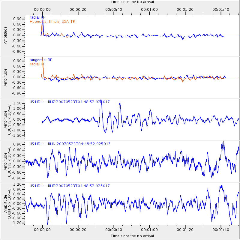
Signal To Noise
| Channel | StoN | STA | LTA |
| US:HDIL: :BHN:20070523T04:48:52.92501Z | 2.1849372 | 3.2649388E-7 | 1.4942941E-7 |
| US:HDIL: :BHE:20070523T04:48:52.92501Z | 3.0170963 | 5.1807655E-7 | 1.7171364E-7 |
| US:HDIL: :BHZ:20070523T04:48:52.92501Z | 7.127799 | 8.3749563E-7 | 1.1749709E-7 |
| Arrivals |
| Ps | 6.5 SECOND |
| PpPs | 18 SECOND |
| PsPs/PpSs | 24 SECOND |


