You are here: Home > Network List > XD14 - Illuminating the architecture of the greater Mount St. Helens magmatic systems f Stations List
> Station MF09 "Mount St Helens, WA" > Earthquake Result Viewer
MF09 "Mount St Helens, WA" - Earthquake Result Viewer
| Earthquake location: |
Oaxaca, Mexico |
| Earthquake latitude/longitude: |
16.6/-97.7 |
| Earthquake time(UTC): |
2016/05/08 (129) 07:34:02 GMT |
| Earthquake Depth: |
24 km |
| Earthquake Magnitude: |
5.9 MB |
| Earthquake Catalog/Contributor: |
NEIC PDE/NEIC ALERT |
|
| Network: |
XD Illuminating the architecture of the greater Mount St. Helens magmatic systems f |
| Station: |
MF09 "Mount St Helens, WA" |
| Lat/Lon: |
46.39 N/121.86 W |
| Elevation: |
1216 m |
|
| Distance: |
35.9 deg |
| Az: |
331.092 deg |
| Baz: |
137.952 deg |
| Ray Param: |
0.076942936 |
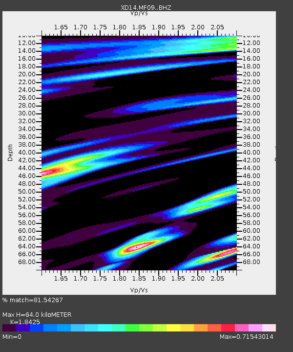
| Estimated Moho Depth: |
64.0 km |
| Estimated Crust Vp/Vs: |
1.84 |
| Assumed Crust Vp: |
6.597 km/s |
| Estimated Crust Vs: |
3.581 km/s |
| Estimated Crust Poisson's Ratio: |
0.29 |
|
| Radial Match: |
81.54267 % |
| Radial Bump: |
400 |
| Transverse Match: |
64.606384 % |
| Transverse Bump: |
400 |
| SOD ConfigId: |
7422571 |
| Insert Time: |
2019-04-22 13:27:08.288 +0000 |
| GWidth: |
2.5 |
| Max Bumps: |
400 |
| Tol: |
0.001 |
|

Signal To Noise
| Channel | StoN | STA | LTA |
| XD:MF09: :BHZ:20160508T07:40:28.959991Z | 10.163176 | 1.8923498E-6 | 1.861967E-7 |
| XD:MF09: :BHN:20160508T07:40:28.959991Z | 4.2468653 | 6.99323E-7 | 1.6466804E-7 |
| XD:MF09: :BHE:20160508T07:40:28.959991Z | 1.9467132 | 4.2862996E-7 | 2.2018135E-7 |
| Arrivals |
| Ps | 8.8 SECOND |
| PpPs | 26 SECOND |
| PsPs/PpSs | 34 SECOND |


