You are here: Home > Network List > XD14 - Illuminating the architecture of the greater Mount St. Helens magmatic systems f Stations List
> Station ML07 "Mount St Helens, WA" > Earthquake Result Viewer
ML07 "Mount St Helens, WA" - Earthquake Result Viewer
| Earthquake location: |
Oaxaca, Mexico |
| Earthquake latitude/longitude: |
16.6/-97.7 |
| Earthquake time(UTC): |
2016/05/08 (129) 07:34:02 GMT |
| Earthquake Depth: |
24 km |
| Earthquake Magnitude: |
5.9 MB |
| Earthquake Catalog/Contributor: |
NEIC PDE/NEIC ALERT |
|
| Network: |
XD Illuminating the architecture of the greater Mount St. Helens magmatic systems f |
| Station: |
ML07 "Mount St Helens, WA" |
| Lat/Lon: |
46.07 N/122.12 W |
| Elevation: |
694 m |
|
| Distance: |
35.8 deg |
| Az: |
330.506 deg |
| Baz: |
137.294 deg |
| Ray Param: |
0.07700517 |
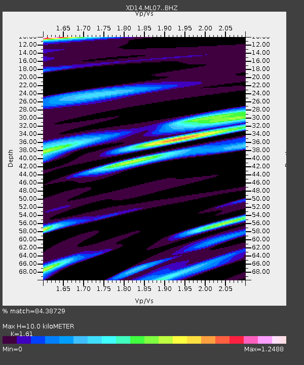
| Estimated Moho Depth: |
10.0 km |
| Estimated Crust Vp/Vs: |
1.61 |
| Assumed Crust Vp: |
6.566 km/s |
| Estimated Crust Vs: |
4.078 km/s |
| Estimated Crust Poisson's Ratio: |
0.19 |
|
| Radial Match: |
84.38729 % |
| Radial Bump: |
400 |
| Transverse Match: |
74.33203 % |
| Transverse Bump: |
400 |
| SOD ConfigId: |
7422571 |
| Insert Time: |
2019-04-22 13:27:34.434 +0000 |
| GWidth: |
2.5 |
| Max Bumps: |
400 |
| Tol: |
0.001 |
|

Signal To Noise
| Channel | StoN | STA | LTA |
| XD:ML07: :BHZ:20160508T07:40:27.975006Z | 9.014464 | 2.0594994E-6 | 2.2846609E-7 |
| XD:ML07: :BHN:20160508T07:40:27.975006Z | 4.2681527 | 9.861395E-7 | 2.3104599E-7 |
| XD:ML07: :BHE:20160508T07:40:27.975006Z | 4.19365 | 1.0228525E-6 | 2.439051E-7 |
| Arrivals |
| Ps | 1.0 SECOND |
| PpPs | 3.6 SECOND |
| PsPs/PpSs | 4.7 SECOND |


