You are here: Home > Network List > US - United States National Seismic Network Stations List
> Station HDIL Hopedale, Illinois, USA > Earthquake Result Viewer
HDIL Hopedale, Illinois, USA - Earthquake Result Viewer
| Earthquake location: |
Samoa Islands Region |
| Earthquake latitude/longitude: |
-15.9/-171.7 |
| Earthquake time(UTC): |
2009/09/29 (272) 18:19:35 GMT |
| Earthquake Depth: |
10 km |
| Earthquake Magnitude: |
5.6 MB |
| Earthquake Catalog/Contributor: |
WHDF/NEIC |
|
| Network: |
US United States National Seismic Network |
| Station: |
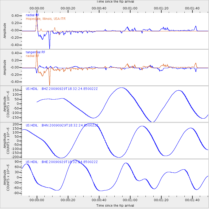
HDIL Hopedale, Illinois, USA |
| Lat/Lon: |
40.56 N/89.29 W |
| Elevation: |
219 m |
|
| Distance: |
94.6 deg |
| Az: |
49.25 deg |
| Baz: |
253.043 deg |
| Ray Param: |
0.04101609 |
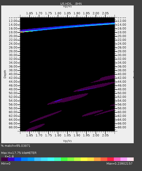
| Estimated Moho Depth: |
17.75 km |
| Estimated Crust Vp/Vs: |
1.60 |
| Assumed Crust Vp: |
6.498 km/s |
| Estimated Crust Vs: |
4.061 km/s |
| Estimated Crust Poisson's Ratio: |
0.18 |
|
| Radial Match: |
95.03871 % |
| Radial Bump: |
364 |
| Transverse Match: |
33.48955 % |
| Transverse Bump: |
400 |
| SOD ConfigId: |
2622 |
| Insert Time: |
2010-03-05 02:59:32.776 +0000 |
| GWidth: |
2.5 |
| Max Bumps: |
400 |
| Tol: |
0.001 |
|
Signal To Noise
| Channel | StoN | STA | LTA |
| US:HDIL: :BHN:20090929T18:32:24.850022Z | 0.37353435 | 3.156498E-5 | 8.450356E-5 |
| US:HDIL: :BHE:20090929T18:32:24.850022Z | 1.6228753 | 5.058063E-5 | 3.1167292E-5 |
| US:HDIL: :BHZ:20090929T18:32:24.850022Z | 6.8681383 | 1.5811152E-4 | 2.3021015E-5 |
| Arrivals |
| Ps | 1.7 SECOND |
| PpPs | 6.9 SECOND |
| PsPs/PpSs | 8.6 SECOND |


