You are here: Home > Network List > US - United States National Seismic Network Stations List
> Station MSO Missoula, Montana, USA > Earthquake Result Viewer
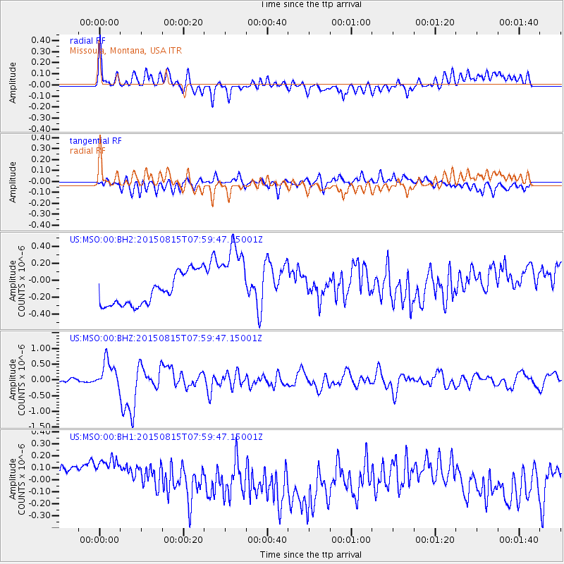
MSO Missoula, Montana, USA - Earthquake Result Viewer
*The percent match for this event was below the threshold and hence no stack was calculated.
| Earthquake location: |
Solomon Islands |
| Earthquake latitude/longitude: |
-10.9/163.9 |
| Earthquake time(UTC): |
2015/08/15 (227) 07:47:06 GMT |
| Earthquake Depth: |
6.4 km |
| Earthquake Magnitude: |
6.6 MWP, 6.6 MI |
| Earthquake Catalog/Contributor: |
NEIC PDE/NEIC COMCAT |
|
| Network: |
US United States National Seismic Network |
| Station: |
MSO Missoula, Montana, USA |
| Lat/Lon: |
46.83 N/113.94 W |
| Elevation: |
1264 m |
|
| Distance: |
92.6 deg |
| Az: |
42.916 deg |
| Baz: |
256.915 deg |
| Ray Param: |
$rayparam |
*The percent match for this event was below the threshold and hence was not used in the summary stack. |
|
| Radial Match: |
39.846333 % |
| Radial Bump: |
400 |
| Transverse Match: |
42.567646 % |
| Transverse Bump: |
400 |
| SOD ConfigId: |
1085051 |
| Insert Time: |
2015-08-29 08:04:35.176 +0000 |
| GWidth: |
2.5 |
| Max Bumps: |
400 |
| Tol: |
0.001 |
|
Signal To Noise
| Channel | StoN | STA | LTA |
| US:MSO:00:BHZ:20150815T07:59:47.15001Z | 6.253341 | 4.4861793E-7 | 7.1740516E-8 |
| US:MSO:00:BH1:20150815T07:59:47.15001Z | 2.0827339 | 2.5314876E-7 | 1.2154636E-7 |
| US:MSO:00:BH2:20150815T07:59:47.15001Z | 2.3451324 | 4.3109625E-7 | 1.8382599E-7 |
| Arrivals |
| Ps | |
| PpPs | |
| PsPs/PpSs | |


