You are here: Home > Network List > US - United States National Seismic Network Stations List
> Station WRAK Wrangell Island, Southeastern Alaska, Alaska, USA > Earthquake Result Viewer
WRAK Wrangell Island, Southeastern Alaska, Alaska, USA - Earthquake Result Viewer
| Earthquake location: |
Solomon Islands |
| Earthquake latitude/longitude: |
-10.9/163.9 |
| Earthquake time(UTC): |
2015/08/15 (227) 07:47:06 GMT |
| Earthquake Depth: |
6.4 km |
| Earthquake Magnitude: |
6.6 MWP, 6.6 MI |
| Earthquake Catalog/Contributor: |
NEIC PDE/NEIC COMCAT |
|
| Network: |
US United States National Seismic Network |
| Station: |
WRAK Wrangell Island, Southeastern Alaska, Alaska, USA |
| Lat/Lon: |
56.42 N/132.35 W |
| Elevation: |
81 m |
|
| Distance: |
85.1 deg |
| Az: |
30.02 deg |
| Baz: |
242.164 deg |
| Ray Param: |
0.044992473 |
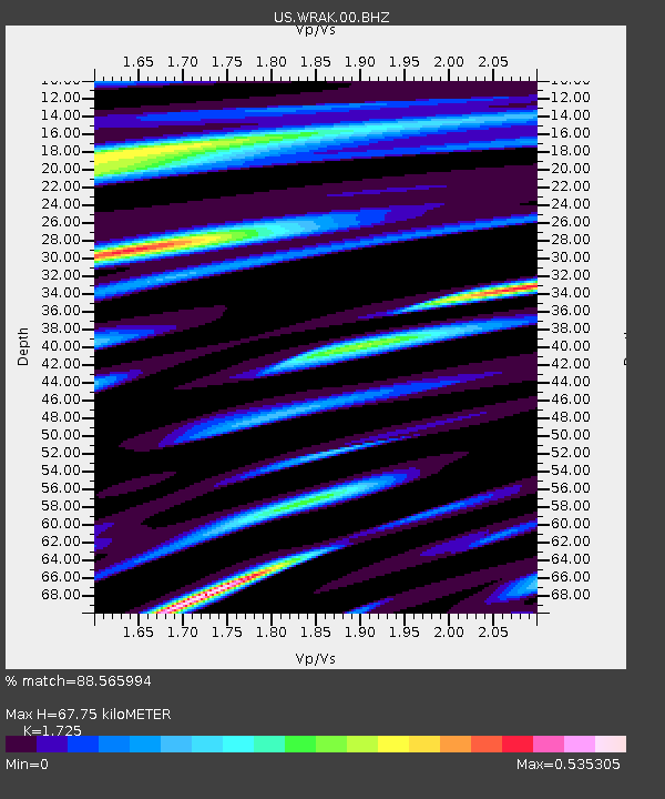
| Estimated Moho Depth: |
67.75 km |
| Estimated Crust Vp/Vs: |
1.73 |
| Assumed Crust Vp: |
6.597 km/s |
| Estimated Crust Vs: |
3.825 km/s |
| Estimated Crust Poisson's Ratio: |
0.25 |
|
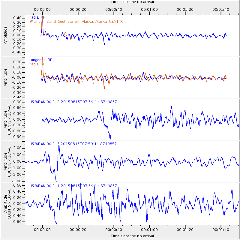
| Radial Match: |
88.565994 % |
| Radial Bump: |
400 |
| Transverse Match: |
79.82863 % |
| Transverse Bump: |
400 |
| SOD ConfigId: |
1085051 |
| Insert Time: |
2015-08-29 08:04:58.543 +0000 |
| GWidth: |
2.5 |
| Max Bumps: |
400 |
| Tol: |
0.001 |
|
Signal To Noise
| Channel | StoN | STA | LTA |
| US:WRAK:00:BHZ:20150815T07:59:11.874985Z | 10.048927 | 7.804182E-7 | 7.766184E-8 |
| US:WRAK:00:BH1:20150815T07:59:11.874985Z | 2.2115178 | 1.4656544E-7 | 6.6273685E-8 |
| US:WRAK:00:BH2:20150815T07:59:11.874985Z | 2.9271898 | 2.2809651E-7 | 7.7923374E-8 |
| Arrivals |
| Ps | 7.6 SECOND |
| PpPs | 27 SECOND |
| PsPs/PpSs | 35 SECOND |


