You are here: Home > Network List > AV - Alaska Volcano Observatory Stations List
> Station MAPS Pakushin Southeast, Makushin Volcano, Alaska > Earthquake Result Viewer
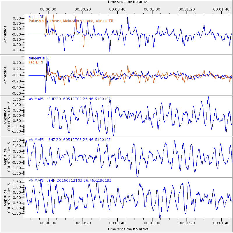
MAPS Pakushin Southeast, Makushin Volcano, Alaska - Earthquake Result Viewer
*The percent match for this event was below the threshold and hence no stack was calculated.
| Earthquake location: |
Taiwan |
| Earthquake latitude/longitude: |
24.7/122.0 |
| Earthquake time(UTC): |
2016/05/12 (133) 03:17:16 GMT |
| Earthquake Depth: |
10 km |
| Earthquake Magnitude: |
5.6 MB |
| Earthquake Catalog/Contributor: |
NEIC PDE/NEIC COMCAT |
|
| Network: |
AV Alaska Volcano Observatory |
| Station: |
MAPS Pakushin Southeast, Makushin Volcano, Alaska |
| Lat/Lon: |
53.81 N/166.94 W |
| Elevation: |
333 m |
|
| Distance: |
59.4 deg |
| Az: |
40.683 deg |
| Baz: |
270.59 deg |
| Ray Param: |
$rayparam |
*The percent match for this event was below the threshold and hence was not used in the summary stack. |
|
| Radial Match: |
52.93613 % |
| Radial Bump: |
385 |
| Transverse Match: |
77.48109 % |
| Transverse Bump: |
400 |
| SOD ConfigId: |
7422571 |
| Insert Time: |
2019-04-22 13:38:51.473 +0000 |
| GWidth: |
2.5 |
| Max Bumps: |
400 |
| Tol: |
0.001 |
|
Signal To Noise
| Channel | StoN | STA | LTA |
| AV:MAPS: :BHZ:20160512T03:26:46.619019Z | 0.8822245 | 5.5975795E-7 | 6.344847E-7 |
| AV:MAPS: :BHN:20160512T03:26:46.619019Z | 1.9751248 | 1.0646021E-6 | 5.3900493E-7 |
| AV:MAPS: :BHE:20160512T03:26:46.619019Z | 1.4220381 | 1.0329579E-6 | 7.2639256E-7 |
| Arrivals |
| Ps | |
| PpPs | |
| PsPs/PpSs | |


