You are here: Home > Network List > US - United States National Seismic Network Stations List
> Station HDIL Hopedale, Illinois, USA > Earthquake Result Viewer
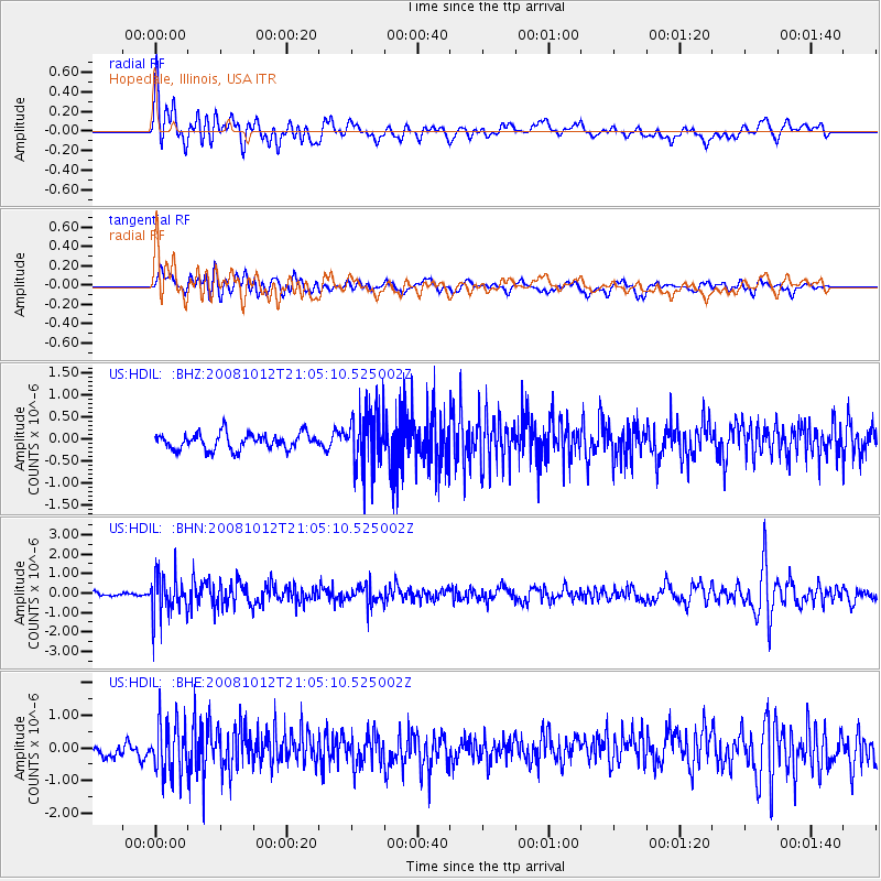
HDIL Hopedale, Illinois, USA - Earthquake Result Viewer
*The percent match for this event was below the threshold and hence no stack was calculated.
| Earthquake location: |
Southern Bolivia |
| Earthquake latitude/longitude: |
-20.1/-65.0 |
| Earthquake time(UTC): |
2008/10/12 (286) 20:55:41 GMT |
| Earthquake Depth: |
353 km |
| Earthquake Magnitude: |
6.0 MB, 6.2 MW, 6.2 MW |
| Earthquake Catalog/Contributor: |
WHDF/NEIC |
|
| Network: |
US United States National Seismic Network |
| Station: |
HDIL Hopedale, Illinois, USA |
| Lat/Lon: |
40.56 N/89.29 W |
| Elevation: |
219 m |
|
| Distance: |
64.5 deg |
| Az: |
339.649 deg |
| Baz: |
154.602 deg |
| Ray Param: |
$rayparam |
*The percent match for this event was below the threshold and hence was not used in the summary stack. |
|
| Radial Match: |
73.8021 % |
| Radial Bump: |
400 |
| Transverse Match: |
52.311398 % |
| Transverse Bump: |
400 |
| SOD ConfigId: |
2556 |
| Insert Time: |
2010-03-05 03:00:46.886 +0000 |
| GWidth: |
2.5 |
| Max Bumps: |
400 |
| Tol: |
0.001 |
|
Signal To Noise
| Channel | StoN | STA | LTA |
| US:HDIL: :BHN:20081012T21:05:10.525002Z | 7.3071523 | 1.0653956E-6 | 1.4580175E-7 |
| US:HDIL: :BHE:20081012T21:05:10.525002Z | 3.6934652 | 7.9625596E-7 | 2.1558508E-7 |
| US:HDIL: :BHZ:20081012T21:05:10.525002Z | 3.6117754 | 6.53332E-7 | 1.8088944E-7 |
| Arrivals |
| Ps | |
| PpPs | |
| PsPs/PpSs | |


