You are here: Home > Network List > CN - Canadian National Seismograph Network Stations List
> Station INK INUVIK, NT > Earthquake Result Viewer
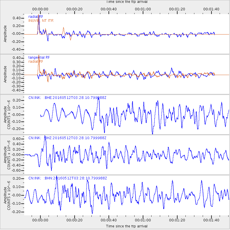
INK INUVIK, NT - Earthquake Result Viewer
*The percent match for this event was below the threshold and hence no stack was calculated.
| Earthquake location: |
Taiwan |
| Earthquake latitude/longitude: |
24.7/122.0 |
| Earthquake time(UTC): |
2016/05/12 (133) 03:17:16 GMT |
| Earthquake Depth: |
10 km |
| Earthquake Magnitude: |
5.6 MB |
| Earthquake Catalog/Contributor: |
NEIC PDE/NEIC COMCAT |
|
| Network: |
CN Canadian National Seismograph Network |
| Station: |
INK INUVIK, NT |
| Lat/Lon: |
68.31 N/133.53 W |
| Elevation: |
44 m |
|
| Distance: |
72.5 deg |
| Az: |
22.172 deg |
| Baz: |
292.562 deg |
| Ray Param: |
$rayparam |
*The percent match for this event was below the threshold and hence was not used in the summary stack. |
|
| Radial Match: |
78.53851 % |
| Radial Bump: |
400 |
| Transverse Match: |
62.89461 % |
| Transverse Bump: |
400 |
| SOD ConfigId: |
7422571 |
| Insert Time: |
2019-04-22 13:39:37.270 +0000 |
| GWidth: |
2.5 |
| Max Bumps: |
400 |
| Tol: |
0.001 |
|
Signal To Noise
| Channel | StoN | STA | LTA |
| CN:INK: :BHZ:20160512T03:28:10.799988Z | 6.3156266 | 3.8489821E-7 | 6.094379E-8 |
| CN:INK: :BHN:20160512T03:28:10.799988Z | 1.4742963 | 5.4403298E-8 | 3.6901195E-8 |
| CN:INK: :BHE:20160512T03:28:10.799988Z | 2.1581054 | 1.4150314E-7 | 6.556822E-8 |
| Arrivals |
| Ps | |
| PpPs | |
| PsPs/PpSs | |


