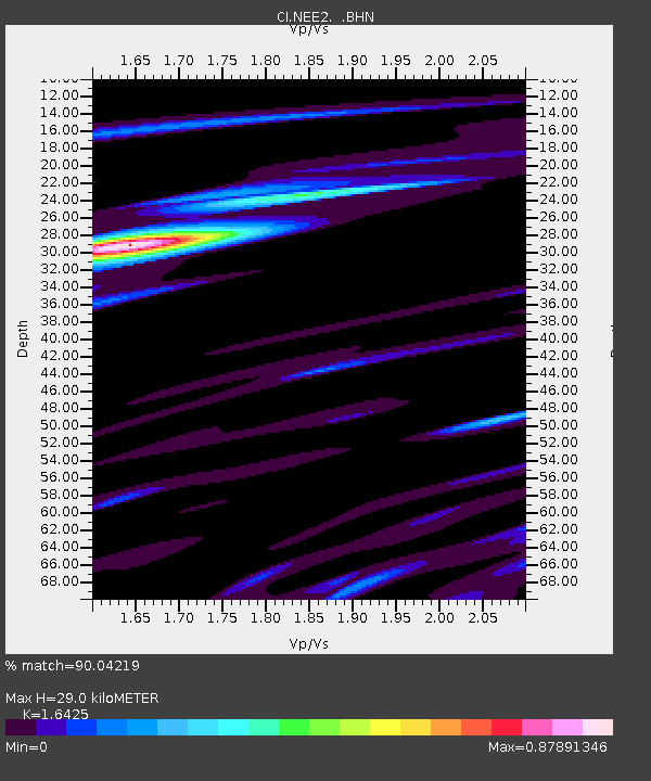
NEE2 Needles Airport - Earthquake Result Viewer
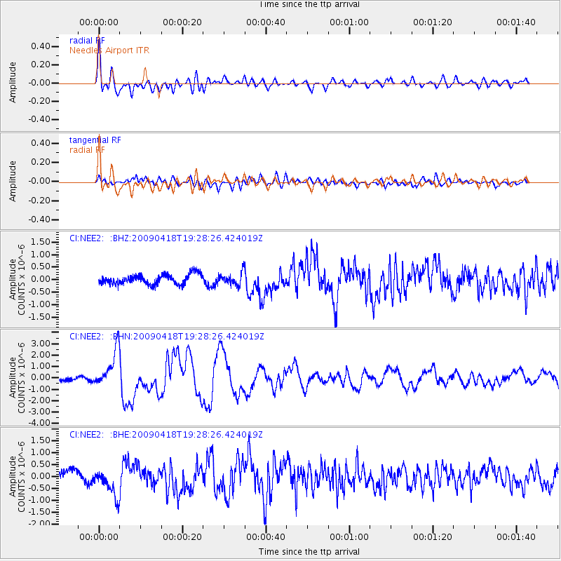
Earthquake location: Kuril Islands
Earthquake latitude/longitude: 46.0/151.4
Earthquake time(UTC): 2009/04/18 (108) 19:17:58 GMT
Earthquake Depth: 35 km
Earthquake Magnitude: 6.3 MB, 6.3 MS, 6.6 MW, 6.4 MW
Earthquake Catalog/Contributor: WHDF/NEIC
Network: CI Caltech Regional Seismic Network
Station: NEE2 Needles Airport
Lat/Lon: 34.77 N/114.62 W
Elevation: 271 m
Distance: 68.4 deg
Az: 62.021 deg
Baz: 311.621 deg
Ray Param: 0.056250475
Estimated Moho Depth: 29.0 km
Estimated Crust Vp/Vs: 1.64
Assumed Crust Vp: 6.276 km/s
Estimated Crust Vs: 3.821 km/s
Estimated Crust Poisson's Ratio: 0.21
Radial Match: 90.04219 %
Radial Bump: 400
Transverse Match: 68.03746 %
Transverse Bump: 400
SOD ConfigId: 2760
Insert Time: 2010-02-26 00:21:09.792 +0000
GWidth: 2.5
Max Bumps: 400
Tol: 0.001

Signal To Noise

ChannelStoNSTALTA
CI:NEE2: :BHN:20090418T19:28:26.424019Z8.1813141.6845905E-62.0590706E-7
CI:NEE2: :BHE:20090418T19:28:26.424019Z3.09417446.3121E-72.039995E-7
CI:NEE2: :BHZ:20090418T19:28:26.424019Z1.27239912.5312212E-71.9893297E-7
Arrivals
Ps3.1 SECOND
PpPs12 SECOND
PsPs/PpSs15 SECOND