You are here: Home > Network List > US - United States National Seismic Network Stations List
> Station HDIL Hopedale, Illinois, USA > Earthquake Result Viewer
HDIL Hopedale, Illinois, USA - Earthquake Result Viewer
*The percent match for this event was below the threshold and hence no stack was calculated.
| Earthquake location: |
Samoa Islands Region |
| Earthquake latitude/longitude: |
-15.4/-172.3 |
| Earthquake time(UTC): |
2009/10/19 (292) 22:49:38 GMT |
| Earthquake Depth: |
18 km |
| Earthquake Magnitude: |
6.2 MB, 5.7 MS, 6.0 MW, 5.9 MW |
| Earthquake Catalog/Contributor: |
WHDF/NEIC |
|
| Network: |
US United States National Seismic Network |
| Station: |
HDIL Hopedale, Illinois, USA |
| Lat/Lon: |
40.56 N/89.29 W |
| Elevation: |
219 m |
|
| Distance: |
94.6 deg |
| Az: |
49.346 deg |
| Baz: |
253.863 deg |
| Ray Param: |
$rayparam |
*The percent match for this event was below the threshold and hence was not used in the summary stack. |
|
| Radial Match: |
44.095295 % |
| Radial Bump: |
400 |
| Transverse Match: |
46.280056 % |
| Transverse Bump: |
400 |
| SOD ConfigId: |
2622 |
| Insert Time: |
2010-03-05 03:01:06.350 +0000 |
| GWidth: |
2.5 |
| Max Bumps: |
400 |
| Tol: |
0.001 |
|
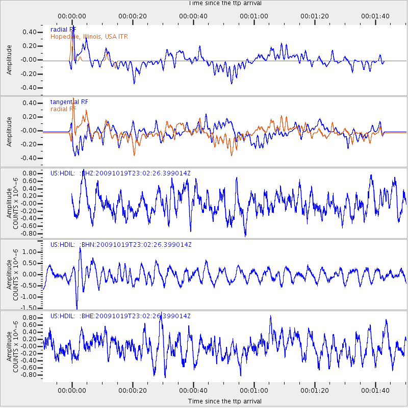
Signal To Noise
| Channel | StoN | STA | LTA |
| US:HDIL: :BHN:20091019T23:02:26.399014Z | 2.4259026 | 6.349895E-7 | 2.6175388E-7 |
| US:HDIL: :BHE:20091019T23:02:26.399014Z | 0.9884752 | 2.7114098E-7 | 2.7430224E-7 |
| US:HDIL: :BHZ:20091019T23:02:26.399014Z | 1.0704817 | 3.1886592E-7 | 2.9787145E-7 |
| Arrivals |
| Ps | |
| PpPs | |
| PsPs/PpSs | |


