You are here: Home > Network List > US - United States National Seismic Network Stations List
> Station KVTX Kingsville, Texas, USA > Earthquake Result Viewer
KVTX Kingsville, Texas, USA - Earthquake Result Viewer
| Earthquake location: |
South Of Fiji Islands |
| Earthquake latitude/longitude: |
-26.0/-177.5 |
| Earthquake time(UTC): |
2007/12/09 (343) 07:28:20 GMT |
| Earthquake Depth: |
152 km |
| Earthquake Magnitude: |
7.0 MB, 7.8 MW, 7.7 MW |
| Earthquake Catalog/Contributor: |
WHDF/NEIC |
|
| Network: |
US United States National Seismic Network |
| Station: |
KVTX Kingsville, Texas, USA |
| Lat/Lon: |
27.55 N/97.89 W |
| Elevation: |
15 m |
|
| Distance: |
93.2 deg |
| Az: |
61.019 deg |
| Baz: |
242.458 deg |
| Ray Param: |
0.04121141 |
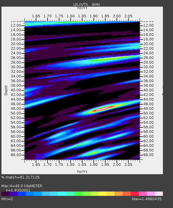
| Estimated Moho Depth: |
48.0 km |
| Estimated Crust Vp/Vs: |
1.93 |
| Assumed Crust Vp: |
5.517 km/s |
| Estimated Crust Vs: |
2.858 km/s |
| Estimated Crust Poisson's Ratio: |
0.32 |
|
| Radial Match: |
91.217125 % |
| Radial Bump: |
400 |
| Transverse Match: |
88.960625 % |
| Transverse Bump: |
400 |
| SOD ConfigId: |
2564 |
| Insert Time: |
2010-03-05 03:01:31.359 +0000 |
| GWidth: |
2.5 |
| Max Bumps: |
400 |
| Tol: |
0.001 |
|
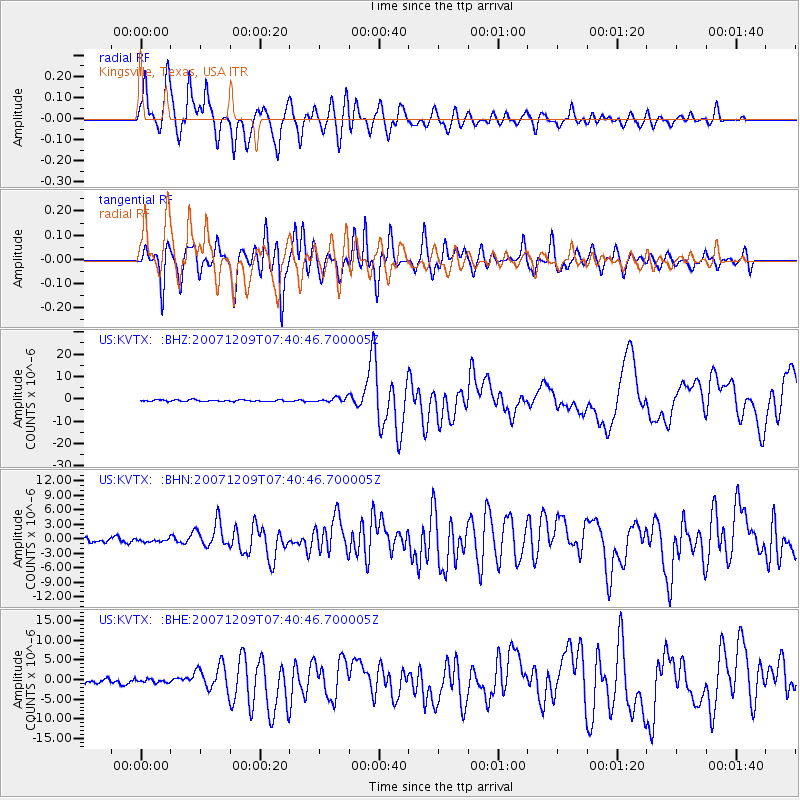
Signal To Noise
| Channel | StoN | STA | LTA |
| US:KVTX: :BHN:20071209T07:40:46.700005Z | 0.59095496 | 3.3240164E-7 | 5.6248217E-7 |
| US:KVTX: :BHE:20071209T07:40:46.700005Z | 0.8402811 | 4.147919E-7 | 4.936347E-7 |
| US:KVTX: :BHZ:20071209T07:40:46.700005Z | 3.1622903 | 1.0985233E-6 | 3.4738218E-7 |
| Arrivals |
| Ps | 8.2 SECOND |
| PpPs | 25 SECOND |
| PsPs/PpSs | 33 SECOND |


