You are here: Home > Network List > US - United States National Seismic Network Stations List
> Station KVTX Kingsville, Texas, USA > Earthquake Result Viewer
KVTX Kingsville, Texas, USA - Earthquake Result Viewer
| Earthquake location: |
South Of Tonga Islands |
| Earthquake latitude/longitude: |
-26.2/-175.6 |
| Earthquake time(UTC): |
2006/09/19 (262) 13:29:54 GMT |
| Earthquake Depth: |
18 km |
| Earthquake Magnitude: |
5.7 MB, 5.4 MS, 5.7 MW, 5.6 MW |
| Earthquake Catalog/Contributor: |
WHDF/NEIC |
|
| Network: |
US United States National Seismic Network |
| Station: |
KVTX Kingsville, Texas, USA |
| Lat/Lon: |
27.55 N/97.89 W |
| Elevation: |
15 m |
|
| Distance: |
91.8 deg |
| Az: |
60.227 deg |
| Baz: |
241.48 deg |
| Ray Param: |
0.04154891 |
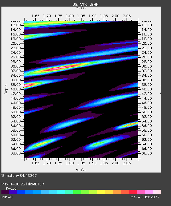
| Estimated Moho Depth: |
38.25 km |
| Estimated Crust Vp/Vs: |
1.60 |
| Assumed Crust Vp: |
5.517 km/s |
| Estimated Crust Vs: |
3.448 km/s |
| Estimated Crust Poisson's Ratio: |
0.18 |
|
| Radial Match: |
84.43367 % |
| Radial Bump: |
225 |
| Transverse Match: |
86.1945 % |
| Transverse Bump: |
210 |
| SOD ConfigId: |
2665 |
| Insert Time: |
2010-03-05 03:01:35.659 +0000 |
| GWidth: |
2.5 |
| Max Bumps: |
400 |
| Tol: |
0.001 |
|
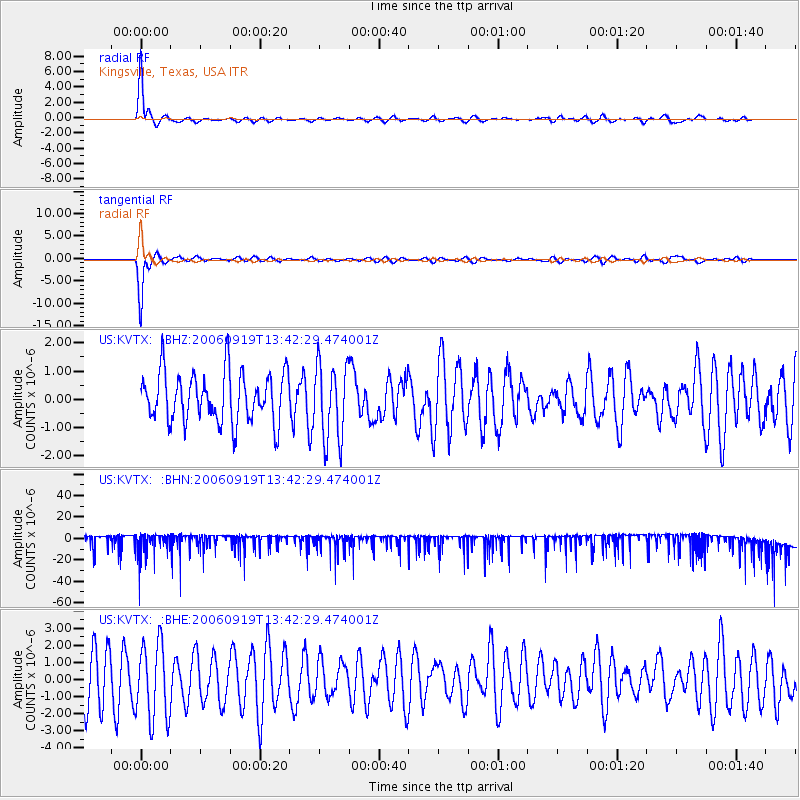
Signal To Noise
| Channel | StoN | STA | LTA |
| US:KVTX: :BHN:20060919T13:42:29.474001Z | 1.706844 | 1.0748434E-5 | 6.2972563E-6 |
| US:KVTX: :BHE:20060919T13:42:29.474001Z | 1.5293149 | 2.2152872E-6 | 1.4485488E-6 |
| US:KVTX: :BHZ:20060919T13:42:29.474001Z | 1.5282563 | 1.3396917E-6 | 8.7661454E-7 |
| Arrivals |
| Ps | 4.2 SECOND |
| PpPs | 18 SECOND |
| PsPs/PpSs | 22 SECOND |


