You are here: Home > Network List > UW - Pacific Northwest Regional Seismic Network Stations List
> Station UMAT Pilot Rock, OR, USA > Earthquake Result Viewer
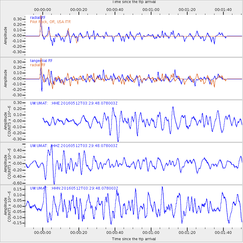
UMAT Pilot Rock, OR, USA - Earthquake Result Viewer
*The percent match for this event was below the threshold and hence no stack was calculated.
| Earthquake location: |
Taiwan |
| Earthquake latitude/longitude: |
24.7/122.0 |
| Earthquake time(UTC): |
2016/05/12 (133) 03:17:16 GMT |
| Earthquake Depth: |
10 km |
| Earthquake Magnitude: |
5.6 MB |
| Earthquake Catalog/Contributor: |
NEIC PDE/NEIC COMCAT |
|
| Network: |
UW Pacific Northwest Regional Seismic Network |
| Station: |
UMAT Pilot Rock, OR, USA |
| Lat/Lon: |
45.29 N/118.96 W |
| Elevation: |
1318 m |
|
| Distance: |
91.0 deg |
| Az: |
38.101 deg |
| Baz: |
307.322 deg |
| Ray Param: |
$rayparam |
*The percent match for this event was below the threshold and hence was not used in the summary stack. |
|
| Radial Match: |
73.53874 % |
| Radial Bump: |
390 |
| Transverse Match: |
59.128063 % |
| Transverse Bump: |
400 |
| SOD ConfigId: |
7422571 |
| Insert Time: |
2019-04-22 13:43:37.322 +0000 |
| GWidth: |
2.5 |
| Max Bumps: |
400 |
| Tol: |
0.001 |
|
Signal To Noise
| Channel | StoN | STA | LTA |
| UW:UMAT: :HHZ:20160512T03:29:48.078003Z | 3.7418447 | 3.13152E-7 | 8.36892E-8 |
| UW:UMAT: :HHN:20160512T03:29:48.078003Z | 1.4992505 | 1.0185576E-7 | 6.793778E-8 |
| UW:UMAT: :HHE:20160512T03:29:48.078003Z | 1.8986288 | 7.182642E-8 | 3.783068E-8 |
| Arrivals |
| Ps | |
| PpPs | |
| PsPs/PpSs | |


