NEE2 Needles Airport - Earthquake Result Viewer
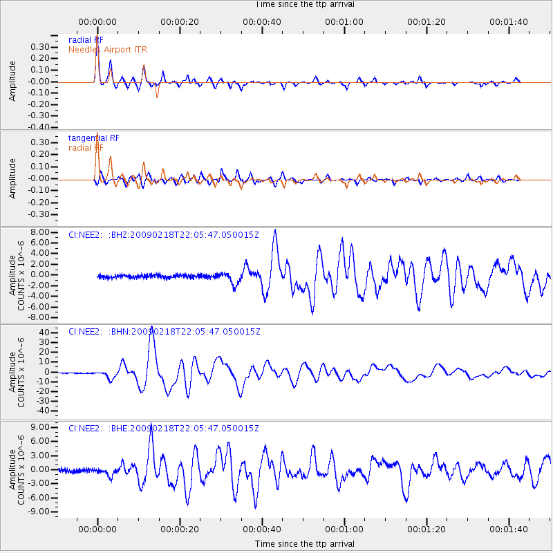
Earthquake location: Kermadec Islands Region
Earthquake latitude/longitude: -27.4/-176.3
Earthquake time(UTC): 2009/02/18 (049) 21:53:45 GMT
Earthquake Depth: 25 km
Earthquake Magnitude: 6.8 MB, 7.2 MS, 6.9 MW, 6.9 MW
Earthquake Catalog/Contributor: WHDF/NEIC
Network: CI Caltech Regional Seismic Network
Station: NEE2 Needles Airport
Lat/Lon: 34.77 N/114.62 W
Elevation: 271 m
Distance: 85.0 deg
Az: 46.692 deg
Baz: 231.784 deg
Ray Param: 0.045034148
Estimated Moho Depth: 26.5 km
Estimated Crust Vp/Vs: 1.75
Assumed Crust Vp: 6.276 km/s
Estimated Crust Vs: 3.586 km/s
Estimated Crust Poisson's Ratio: 0.26
Radial Match: 96.98692 %
Radial Bump: 280
Transverse Match: 94.247574 %
Transverse Bump: 400
SOD ConfigId: 2658
Insert Time: 2010-02-26 00:21:18.828 +0000
GWidth: 2.5
Max Bumps: 400
Tol: 0.001

Signal To Noise

ChannelStoNSTALTA
CI:NEE2: :BHN:20090218T22:05:47.050015Z18.7104994.037939E-62.158114E-7
CI:NEE2: :BHE:20090218T22:05:47.050015Z2.74390347.619578E-72.7769119E-7
CI:NEE2: :BHZ:20090218T22:05:47.050015Z4.46023131.1153035E-62.5005508E-7
Arrivals
Ps3.2 SECOND
PpPs11 SECOND
PsPs/PpSs15 SECOND