You are here: Home > Network List > US - United States National Seismic Network Stations List
> Station AMTX Amarillo, Texas, USA > Earthquake Result Viewer
AMTX Amarillo, Texas, USA - Earthquake Result Viewer
| Earthquake location: |
Near West Coast Of Colombia |
| Earthquake latitude/longitude: |
4.7/-77.5 |
| Earthquake time(UTC): |
2004/11/15 (320) 09:06:56 GMT |
| Earthquake Depth: |
15 km |
| Earthquake Magnitude: |
6.6 MB, 7.1 MS, 7.2 MW, 7.1 MW |
| Earthquake Catalog/Contributor: |
WHDF/NEIC |
|
| Network: |
US United States National Seismic Network |
| Station: |
AMTX Amarillo, Texas, USA |
| Lat/Lon: |
34.53 N/101.41 W |
| Elevation: |
1010 m |
|
| Distance: |
37.0 deg |
| Az: |
326.272 deg |
| Baz: |
137.909 deg |
| Ray Param: |
0.07633891 |
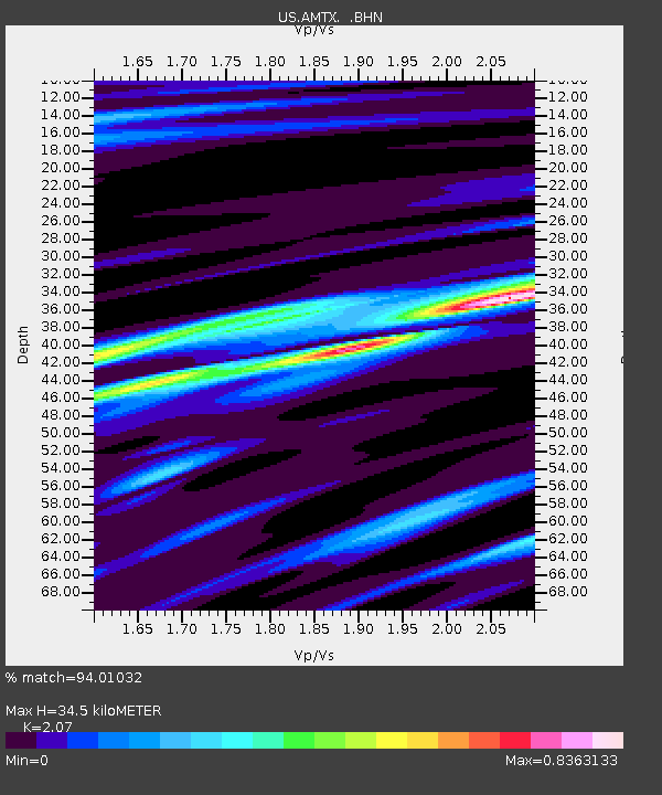
| Estimated Moho Depth: |
34.5 km |
| Estimated Crust Vp/Vs: |
2.07 |
| Assumed Crust Vp: |
6.426 km/s |
| Estimated Crust Vs: |
3.104 km/s |
| Estimated Crust Poisson's Ratio: |
0.35 |
|
| Radial Match: |
94.01032 % |
| Radial Bump: |
205 |
| Transverse Match: |
85.603424 % |
| Transverse Bump: |
400 |
| SOD ConfigId: |
110177 |
| Insert Time: |
2010-03-05 03:02:49.818 +0000 |
| GWidth: |
2.5 |
| Max Bumps: |
400 |
| Tol: |
0.001 |
|

Signal To Noise
| Channel | StoN | STA | LTA |
| US:AMTX: :BHN:20041115T09:13:34.932986Z | 1.2732368 | 3.3162374E-7 | 2.6045726E-7 |
| US:AMTX: :BHE:20041115T09:13:34.932986Z | 1.640324 | 3.0431474E-7 | 1.8552112E-7 |
| US:AMTX: :BHZ:20041115T09:13:34.932986Z | 5.008091 | 9.02218E-7 | 1.8015209E-7 |
| Arrivals |
| Ps | 6.1 SECOND |
| PpPs | 15 SECOND |
| PsPs/PpSs | 22 SECOND |


