You are here: Home > Network List > TA - USArray Transportable Network (new EarthScope stations) Stations List
> Station A21K Barrow, AK, USA > Earthquake Result Viewer
A21K Barrow, AK, USA - Earthquake Result Viewer
*The percent match for this event was below the threshold and hence no stack was calculated.
| Earthquake location: |
Taiwan Region |
| Earthquake latitude/longitude: |
24.7/122.0 |
| Earthquake time(UTC): |
2016/05/12 (133) 04:29:56 GMT |
| Earthquake Depth: |
10 km |
| Earthquake Magnitude: |
5.5 MB |
| Earthquake Catalog/Contributor: |
NEIC PDE/NEIC COMCAT |
|
| Network: |
TA USArray Transportable Network (new EarthScope stations) |
| Station: |
A21K Barrow, AK, USA |
| Lat/Lon: |
71.32 N/156.62 W |
| Elevation: |
577 m |
|
| Distance: |
64.1 deg |
| Az: |
20.742 deg |
| Baz: |
270.266 deg |
| Ray Param: |
$rayparam |
*The percent match for this event was below the threshold and hence was not used in the summary stack. |
|
| Radial Match: |
75.43696 % |
| Radial Bump: |
400 |
| Transverse Match: |
66.94797 % |
| Transverse Bump: |
400 |
| SOD ConfigId: |
7422571 |
| Insert Time: |
2019-04-22 13:50:33.193 +0000 |
| GWidth: |
2.5 |
| Max Bumps: |
400 |
| Tol: |
0.001 |
|
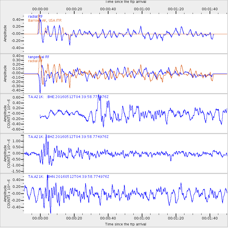
Signal To Noise
| Channel | StoN | STA | LTA |
| TA:A21K: :BHZ:20160512T04:39:58.774976Z | 9.765018 | 6.409063E-7 | 6.563288E-8 |
| TA:A21K: :BHN:20160512T04:39:58.774976Z | 1.9877647 | 2.139404E-7 | 1.0762863E-7 |
| TA:A21K: :BHE:20160512T04:39:58.774976Z | 4.428942 | 3.567359E-7 | 8.054653E-8 |
| Arrivals |
| Ps | |
| PpPs | |
| PsPs/PpSs | |


