You are here: Home > Network List > TA - USArray Transportable Network (new EarthScope stations) Stations List
> Station J04D Umpqua National Forest, Toketee, OR, USA > Earthquake Result Viewer
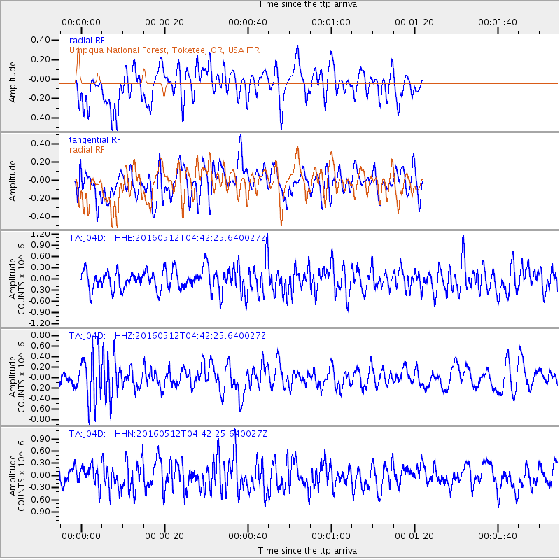
J04D Umpqua National Forest, Toketee, OR, USA - Earthquake Result Viewer
*The percent match for this event was below the threshold and hence no stack was calculated.
| Earthquake location: |
Taiwan Region |
| Earthquake latitude/longitude: |
24.7/122.0 |
| Earthquake time(UTC): |
2016/05/12 (133) 04:29:56 GMT |
| Earthquake Depth: |
10 km |
| Earthquake Magnitude: |
5.5 MB |
| Earthquake Catalog/Contributor: |
NEIC PDE/NEIC COMCAT |
|
| Network: |
TA USArray Transportable Network (new EarthScope stations) |
| Station: |
J04D Umpqua National Forest, Toketee, OR, USA |
| Lat/Lon: |
43.24 N/122.11 W |
| Elevation: |
1948 m |
|
| Distance: |
90.4 deg |
| Az: |
41.122 deg |
| Baz: |
305.047 deg |
| Ray Param: |
$rayparam |
*The percent match for this event was below the threshold and hence was not used in the summary stack. |
|
| Radial Match: |
66.83195 % |
| Radial Bump: |
400 |
| Transverse Match: |
51.99603 % |
| Transverse Bump: |
400 |
| SOD ConfigId: |
7422571 |
| Insert Time: |
2019-04-22 13:50:43.552 +0000 |
| GWidth: |
2.5 |
| Max Bumps: |
400 |
| Tol: |
0.001 |
|
Signal To Noise
| Channel | StoN | STA | LTA |
| TA:J04D: :HHZ:20160512T04:42:25.640027Z | 3.2820945 | 4.54449E-7 | 1.3846311E-7 |
| TA:J04D: :HHN:20160512T04:42:25.640027Z | 0.85925883 | 2.5567493E-7 | 2.9755287E-7 |
| TA:J04D: :HHE:20160512T04:42:25.640027Z | 1.5094365 | 3.6912954E-7 | 2.445479E-7 |
| Arrivals |
| Ps | |
| PpPs | |
| PsPs/PpSs | |


