You are here: Home > Network List > US - United States National Seismic Network Stations List
> Station AMTX Amarillo, Texas, USA > Earthquake Result Viewer
AMTX Amarillo, Texas, USA - Earthquake Result Viewer
| Earthquake location: |
Tonga Islands |
| Earthquake latitude/longitude: |
-19.4/-173.8 |
| Earthquake time(UTC): |
2005/05/04 (124) 08:57:01 GMT |
| Earthquake Depth: |
23 km |
| Earthquake Magnitude: |
5.7 MB, 5.5 MS, 5.9 MW |
| Earthquake Catalog/Contributor: |
WHDF/NEIC |
|
| Network: |
US United States National Seismic Network |
| Station: |
AMTX Amarillo, Texas, USA |
| Lat/Lon: |
34.53 N/101.41 W |
| Elevation: |
1010 m |
|
| Distance: |
87.2 deg |
| Az: |
51.998 deg |
| Baz: |
244.274 deg |
| Ray Param: |
0.043477833 |
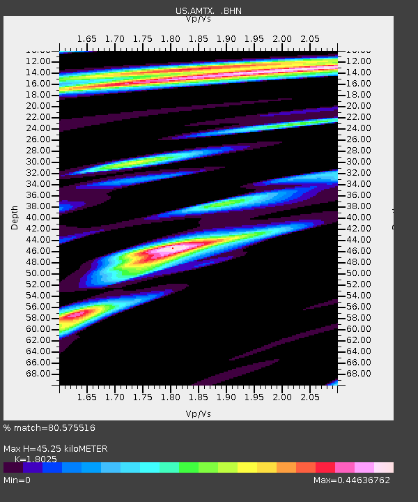
| Estimated Moho Depth: |
45.25 km |
| Estimated Crust Vp/Vs: |
1.80 |
| Assumed Crust Vp: |
6.426 km/s |
| Estimated Crust Vs: |
3.565 km/s |
| Estimated Crust Poisson's Ratio: |
0.28 |
|
| Radial Match: |
80.575516 % |
| Radial Bump: |
400 |
| Transverse Match: |
69.08803 % |
| Transverse Bump: |
400 |
| SOD ConfigId: |
110165 |
| Insert Time: |
2010-03-05 03:03:11.672 +0000 |
| GWidth: |
2.5 |
| Max Bumps: |
400 |
| Tol: |
0.001 |
|
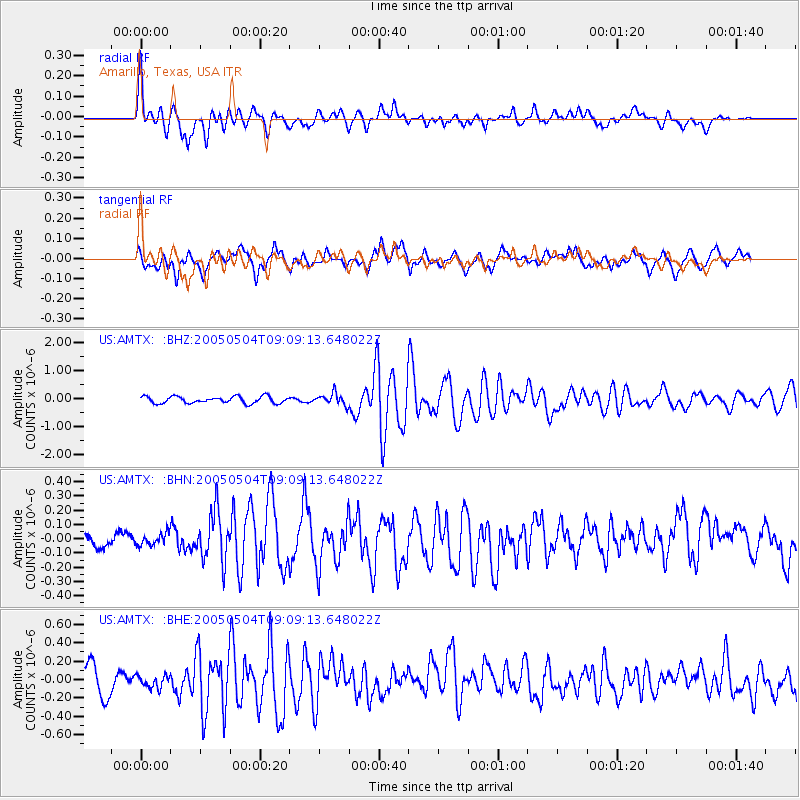
Signal To Noise
| Channel | StoN | STA | LTA |
| US:AMTX: :BHN:20050504T09:09:13.648022Z | 0.4236072 | 4.269043E-8 | 1.00778344E-7 |
| US:AMTX: :BHE:20050504T09:09:13.648022Z | 0.66852504 | 7.417356E-8 | 1.1095106E-7 |
| US:AMTX: :BHZ:20050504T09:09:13.648022Z | 1.8065732 | 2.1562852E-7 | 1.1935775E-7 |
| Arrivals |
| Ps | 5.8 SECOND |
| PpPs | 19 SECOND |
| PsPs/PpSs | 25 SECOND |


