You are here: Home > Network List > US - United States National Seismic Network Stations List
> Station AMTX Amarillo, Texas, USA > Earthquake Result Viewer
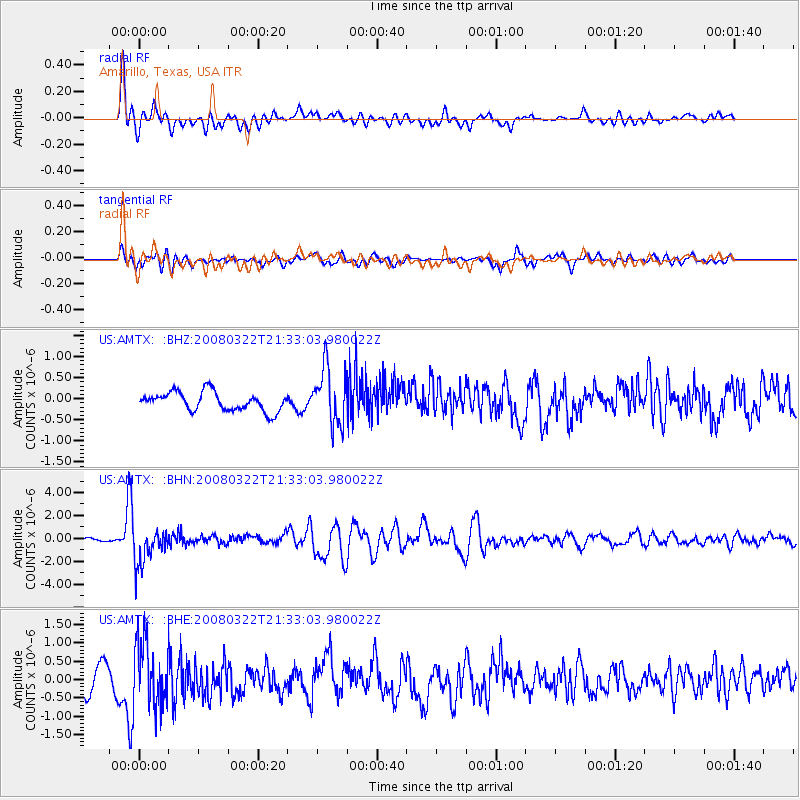
AMTX Amarillo, Texas, USA - Earthquake Result Viewer
*The percent match for this event was below the threshold and hence no stack was calculated.
| Earthquake location: |
Andreanof Islands, Aleutian Is. |
| Earthquake latitude/longitude: |
52.2/-178.7 |
| Earthquake time(UTC): |
2008/03/22 (082) 21:24:11 GMT |
| Earthquake Depth: |
132 km |
| Earthquake Magnitude: |
5.8 MB, 6.2 MW, 6.1 MW |
| Earthquake Catalog/Contributor: |
WHDF/NEIC |
|
| Network: |
US United States National Seismic Network |
| Station: |
AMTX Amarillo, Texas, USA |
| Lat/Lon: |
34.53 N/101.41 W |
| Elevation: |
1010 m |
|
| Distance: |
56.2 deg |
| Az: |
75.75 deg |
| Baz: |
313.702 deg |
| Ray Param: |
$rayparam |
*The percent match for this event was below the threshold and hence was not used in the summary stack. |
|
| Radial Match: |
72.38174 % |
| Radial Bump: |
400 |
| Transverse Match: |
63.45741 % |
| Transverse Bump: |
400 |
| SOD ConfigId: |
2504 |
| Insert Time: |
2010-03-05 03:03:27.951 +0000 |
| GWidth: |
2.5 |
| Max Bumps: |
400 |
| Tol: |
0.001 |
|
Signal To Noise
| Channel | StoN | STA | LTA |
| US:AMTX: :BHN:20080322T21:33:03.980022Z | 9.595894 | 1.5944269E-6 | 1.6615719E-7 |
| US:AMTX: :BHE:20080322T21:33:03.980022Z | 2.6916234 | 8.8842495E-7 | 3.300703E-7 |
| US:AMTX: :BHZ:20080322T21:33:03.980022Z | 2.7071486 | 6.182139E-7 | 2.2836349E-7 |
| Arrivals |
| Ps | |
| PpPs | |
| PsPs/PpSs | |


