You are here: Home > Network List > US - United States National Seismic Network Stations List
> Station AMTX Amarillo, Texas, USA > Earthquake Result Viewer
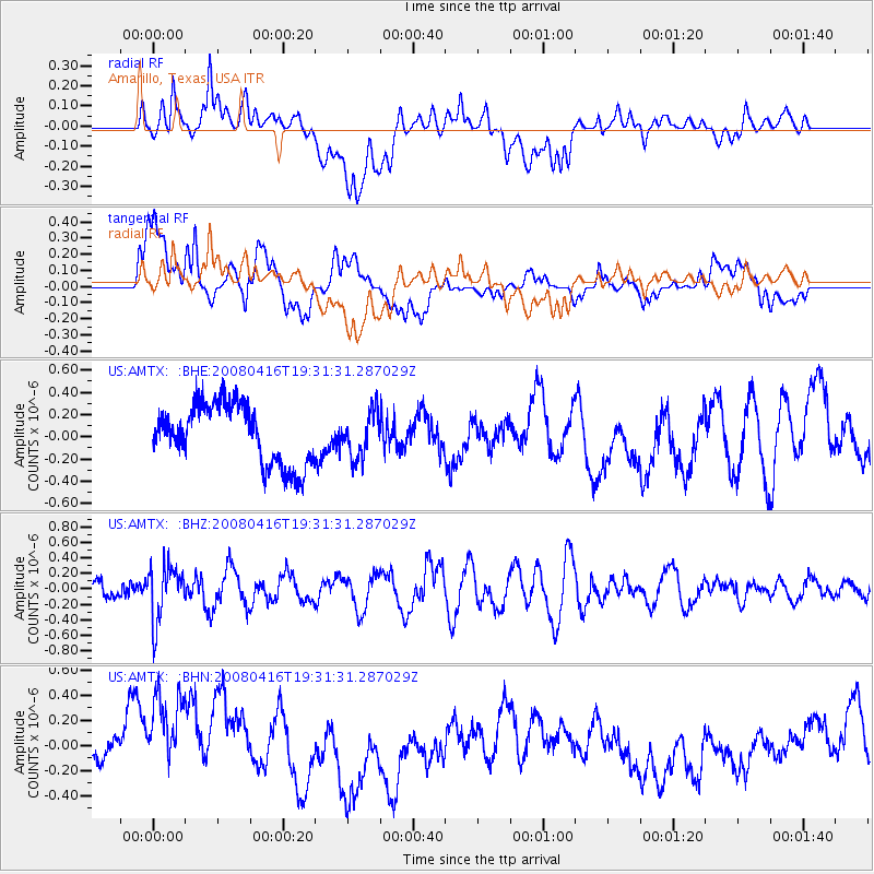
AMTX Amarillo, Texas, USA - Earthquake Result Viewer
*The percent match for this event was below the threshold and hence no stack was calculated.
| Earthquake location: |
Eastern Honshu, Japan |
| Earthquake latitude/longitude: |
39.0/140.0 |
| Earthquake time(UTC): |
2008/04/16 (107) 19:19:36 GMT |
| Earthquake Depth: |
166 km |
| Earthquake Magnitude: |
5.6 MB, 5.8 MW, 5.8 MW |
| Earthquake Catalog/Contributor: |
WHDF/NEIC |
|
| Network: |
US United States National Seismic Network |
| Station: |
AMTX Amarillo, Texas, USA |
| Lat/Lon: |
34.53 N/101.41 W |
| Elevation: |
1010 m |
|
| Distance: |
87.4 deg |
| Az: |
46.53 deg |
| Baz: |
316.79 deg |
| Ray Param: |
$rayparam |
*The percent match for this event was below the threshold and hence was not used in the summary stack. |
|
| Radial Match: |
31.567415 % |
| Radial Bump: |
400 |
| Transverse Match: |
44.374474 % |
| Transverse Bump: |
400 |
| SOD ConfigId: |
2504 |
| Insert Time: |
2010-03-05 03:03:39.778 +0000 |
| GWidth: |
2.5 |
| Max Bumps: |
400 |
| Tol: |
0.001 |
|
Signal To Noise
| Channel | StoN | STA | LTA |
| US:AMTX: :BHZ:20080416T19:31:31.287029Z | 3.4596117 | 3.5111856E-7 | 1.0149075E-7 |
| US:AMTX: :BHN:20080416T19:31:31.287029Z | 3.4749577 | 4.5155718E-7 | 1.2994609E-7 |
| US:AMTX: :BHE:20080416T19:31:31.287029Z | 0.7408984 | 2.0271577E-7 | 2.7360807E-7 |
| Arrivals |
| Ps | |
| PpPs | |
| PsPs/PpSs | |


