You are here: Home > Network List > US - United States National Seismic Network Stations List
> Station AMTX Amarillo, Texas, USA > Earthquake Result Viewer
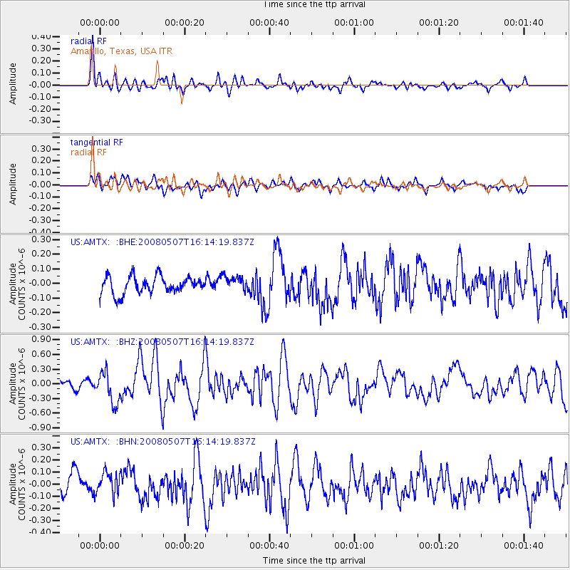
AMTX Amarillo, Texas, USA - Earthquake Result Viewer
*The percent match for this event was below the threshold and hence no stack was calculated.
| Earthquake location: |
Near East Coast Of Honshu, Japan |
| Earthquake latitude/longitude: |
36.2/141.5 |
| Earthquake time(UTC): |
2008/05/07 (128) 16:02:02 GMT |
| Earthquake Depth: |
19 km |
| Earthquake Magnitude: |
5.7 MB, 6.2 MW, 6.2 MW |
| Earthquake Catalog/Contributor: |
WHDF/NEIC |
|
| Network: |
US United States National Seismic Network |
| Station: |
AMTX Amarillo, Texas, USA |
| Lat/Lon: |
34.53 N/101.41 W |
| Elevation: |
1010 m |
|
| Distance: |
88.4 deg |
| Az: |
47.358 deg |
| Baz: |
313.874 deg |
| Ray Param: |
$rayparam |
*The percent match for this event was below the threshold and hence was not used in the summary stack. |
|
| Radial Match: |
74.3536 % |
| Radial Bump: |
400 |
| Transverse Match: |
65.81204 % |
| Transverse Bump: |
400 |
| SOD ConfigId: |
2504 |
| Insert Time: |
2010-03-05 03:03:51.204 +0000 |
| GWidth: |
2.5 |
| Max Bumps: |
400 |
| Tol: |
0.001 |
|
Signal To Noise
| Channel | StoN | STA | LTA |
| US:AMTX: :BHZ:20080507T16:14:19.837Z | 4.6704626 | 3.2472573E-7 | 6.952753E-8 |
| US:AMTX: :BHN:20080507T16:14:19.837Z | 1.0749788 | 8.8552866E-8 | 8.237638E-8 |
| US:AMTX: :BHE:20080507T16:14:19.837Z | 0.8345167 | 4.760929E-8 | 5.7050134E-8 |
| Arrivals |
| Ps | |
| PpPs | |
| PsPs/PpSs | |


