You are here: Home > Network List > US - United States National Seismic Network Stations List
> Station AMTX Amarillo, Texas, USA > Earthquake Result Viewer
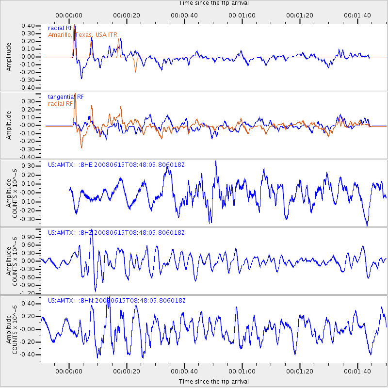
AMTX Amarillo, Texas, USA - Earthquake Result Viewer
*The percent match for this event was below the threshold and hence no stack was calculated.
| Earthquake location: |
Southern East Pacific Rise |
| Earthquake latitude/longitude: |
-36.6/-107.4 |
| Earthquake time(UTC): |
2008/06/15 (167) 08:37:17 GMT |
| Earthquake Depth: |
10 km |
| Earthquake Magnitude: |
5.5 MB, 5.4 MS, 6.0 MW, 6.0 MW |
| Earthquake Catalog/Contributor: |
WHDF/NEIC |
|
| Network: |
US United States National Seismic Network |
| Station: |
AMTX Amarillo, Texas, USA |
| Lat/Lon: |
34.53 N/101.41 W |
| Elevation: |
1010 m |
|
| Distance: |
71.0 deg |
| Az: |
5.273 deg |
| Baz: |
185.137 deg |
| Ray Param: |
$rayparam |
*The percent match for this event was below the threshold and hence was not used in the summary stack. |
|
| Radial Match: |
70.455154 % |
| Radial Bump: |
400 |
| Transverse Match: |
61.7597 % |
| Transverse Bump: |
400 |
| SOD ConfigId: |
2504 |
| Insert Time: |
2010-03-05 03:04:15.982 +0000 |
| GWidth: |
2.5 |
| Max Bumps: |
400 |
| Tol: |
0.001 |
|
Signal To Noise
| Channel | StoN | STA | LTA |
| US:AMTX: :BHZ:20080615T08:48:05.806018Z | 3.0576444 | 3.0195824E-7 | 9.875519E-8 |
| US:AMTX: :BHN:20080615T08:48:05.806018Z | 1.1989679 | 1.0141571E-7 | 8.458584E-8 |
| US:AMTX: :BHE:20080615T08:48:05.806018Z | 0.9824147 | 8.2251866E-8 | 8.372418E-8 |
| Arrivals |
| Ps | |
| PpPs | |
| PsPs/PpSs | |


