You are here: Home > Network List > US - United States National Seismic Network Stations List
> Station AMTX Amarillo, Texas, USA > Earthquake Result Viewer
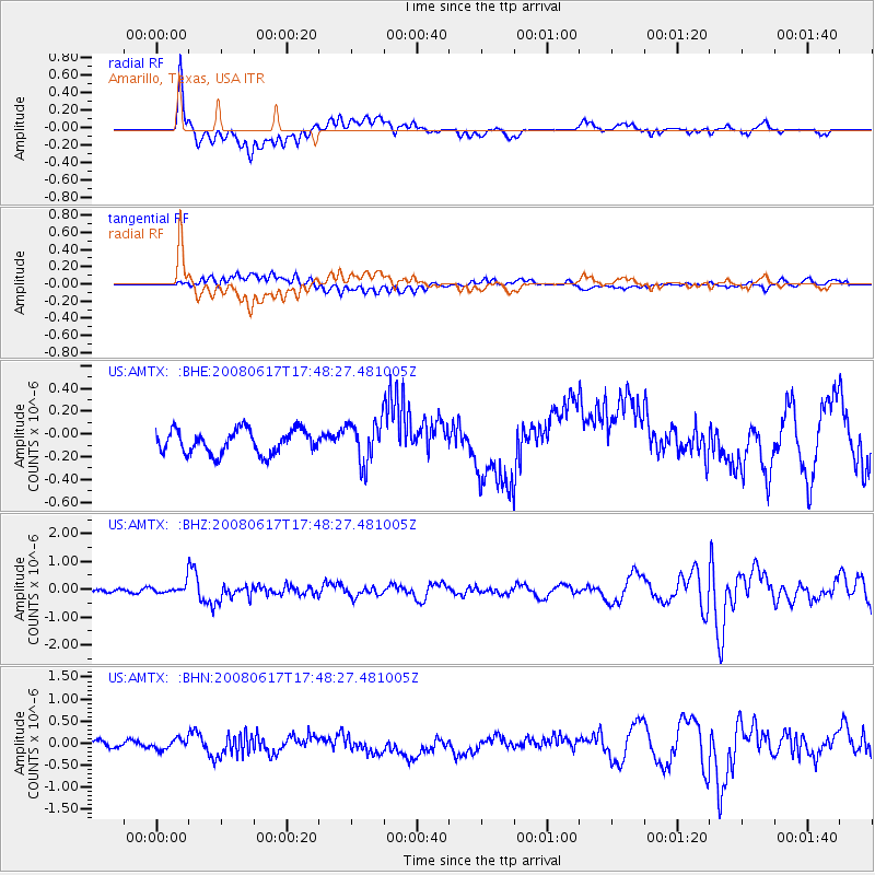
AMTX Amarillo, Texas, USA - Earthquake Result Viewer
*The percent match for this event was below the threshold and hence no stack was calculated.
| Earthquake location: |
South Of Panama |
| Earthquake latitude/longitude: |
5.0/-82.7 |
| Earthquake time(UTC): |
2008/06/17 (169) 17:42:09 GMT |
| Earthquake Depth: |
10 km |
| Earthquake Magnitude: |
5.6 MB, 5.3 MS, 5.9 MW, 5.9 MW |
| Earthquake Catalog/Contributor: |
WHDF/NEIC |
|
| Network: |
US United States National Seismic Network |
| Station: |
AMTX Amarillo, Texas, USA |
| Lat/Lon: |
34.53 N/101.41 W |
| Elevation: |
1010 m |
|
| Distance: |
34.1 deg |
| Az: |
331.764 deg |
| Baz: |
145.187 deg |
| Ray Param: |
$rayparam |
*The percent match for this event was below the threshold and hence was not used in the summary stack. |
|
| Radial Match: |
79.09613 % |
| Radial Bump: |
400 |
| Transverse Match: |
53.56076 % |
| Transverse Bump: |
400 |
| SOD ConfigId: |
2504 |
| Insert Time: |
2010-03-05 03:04:16.607 +0000 |
| GWidth: |
2.5 |
| Max Bumps: |
400 |
| Tol: |
0.001 |
|
Signal To Noise
| Channel | StoN | STA | LTA |
| US:AMTX: :BHZ:20080617T17:48:27.481005Z | 3.2137175 | 1.8763943E-7 | 5.8387037E-8 |
| US:AMTX: :BHN:20080617T17:48:27.481005Z | 1.128055 | 1.1729726E-7 | 1.0398186E-7 |
| US:AMTX: :BHE:20080617T17:48:27.481005Z | 1.0582712 | 1.0945102E-7 | 1.0342436E-7 |
| Arrivals |
| Ps | |
| PpPs | |
| PsPs/PpSs | |


