You are here: Home > Network List > US - United States National Seismic Network Stations List
> Station AMTX Amarillo, Texas, USA > Earthquake Result Viewer
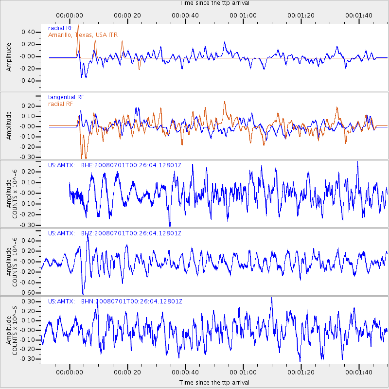
AMTX Amarillo, Texas, USA - Earthquake Result Viewer
*The percent match for this event was below the threshold and hence no stack was calculated.
| Earthquake location: |
Central Peru |
| Earthquake latitude/longitude: |
-10.4/-75.5 |
| Earthquake time(UTC): |
2008/07/01 (183) 00:17:33 GMT |
| Earthquake Depth: |
33 km |
| Earthquake Magnitude: |
5.5 MW, 5.0 MS, 5.4 MB, 5.3 ML |
| Earthquake Catalog/Contributor: |
WHDF/NEIC |
|
| Network: |
US United States National Seismic Network |
| Station: |
AMTX Amarillo, Texas, USA |
| Lat/Lon: |
34.53 N/101.41 W |
| Elevation: |
1010 m |
|
| Distance: |
51.0 deg |
| Az: |
332.34 deg |
| Baz: |
146.411 deg |
| Ray Param: |
$rayparam |
*The percent match for this event was below the threshold and hence was not used in the summary stack. |
|
| Radial Match: |
44.77871 % |
| Radial Bump: |
400 |
| Transverse Match: |
34.88181 % |
| Transverse Bump: |
400 |
| SOD ConfigId: |
2504 |
| Insert Time: |
2010-03-05 03:04:18.575 +0000 |
| GWidth: |
2.5 |
| Max Bumps: |
400 |
| Tol: |
0.001 |
|
Signal To Noise
| Channel | StoN | STA | LTA |
| US:AMTX: :BHZ:20080701T00:26:04.12801Z | 2.8712308 | 2.4258264E-7 | 8.448733E-8 |
| US:AMTX: :BHN:20080701T00:26:04.12801Z | 0.7445022 | 6.490795E-8 | 8.7183025E-8 |
| US:AMTX: :BHE:20080701T00:26:04.12801Z | 0.4628977 | 5.0863793E-8 | 1.09881285E-7 |
| Arrivals |
| Ps | |
| PpPs | |
| PsPs/PpSs | |


