You are here: Home > Network List > US - United States National Seismic Network Stations List
> Station AMTX Amarillo, Texas, USA > Earthquake Result Viewer
AMTX Amarillo, Texas, USA - Earthquake Result Viewer
*The percent match for this event was below the threshold and hence no stack was calculated.
| Earthquake location: |
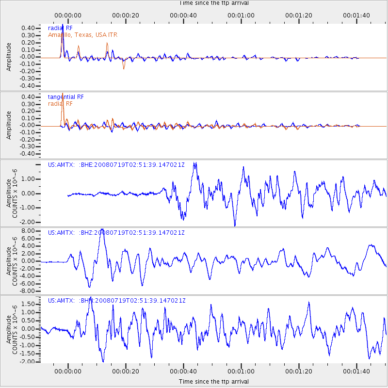
Off East Coast Of Honshu, Japan |
| Earthquake latitude/longitude: |
37.6/142.2 |
| Earthquake time(UTC): |
2008/07/19 (201) 02:39:28 GMT |
| Earthquake Depth: |
22 km |
| Earthquake Magnitude: |
6.2 MB, 7.0 MS, 7.0 MW, 6.9 MW |
| Earthquake Catalog/Contributor: |
WHDF/NEIC |
|
| Network: |
US United States National Seismic Network |
| Station: |
AMTX Amarillo, Texas, USA |
| Lat/Lon: |
34.53 N/101.41 W |
| Elevation: |
1010 m |
|
| Distance: |
87.1 deg |
| Az: |
47.783 deg |
| Baz: |
314.524 deg |
| Ray Param: |
$rayparam |
*The percent match for this event was below the threshold and hence was not used in the summary stack. |
|
| Radial Match: |
97.012535 % |
| Radial Bump: |
327 |
| Transverse Match: |
90.190605 % |
| Transverse Bump: |
400 |
| SOD ConfigId: |
2504 |
| Insert Time: |
2010-03-05 03:04:22.628 +0000 |
| GWidth: |
2.5 |
| Max Bumps: |
400 |
| Tol: |
0.001 |
|
Signal To Noise
| Channel | StoN | STA | LTA |
| US:AMTX: :BHZ:20080719T02:51:39.147021Z | 19.798992 | 1.3941795E-6 | 7.04167E-8 |
| US:AMTX: :BHN:20080719T02:51:39.147021Z | 3.4926257 | 3.0422507E-7 | 8.710497E-8 |
| US:AMTX: :BHE:20080719T02:51:39.147021Z | 5.2431984 | 3.3128447E-7 | 6.3183656E-8 |
| Arrivals |
| Ps | |
| PpPs | |
| PsPs/PpSs | |


