You are here: Home > Network List > US - United States National Seismic Network Stations List
> Station AMTX Amarillo, Texas, USA > Earthquake Result Viewer
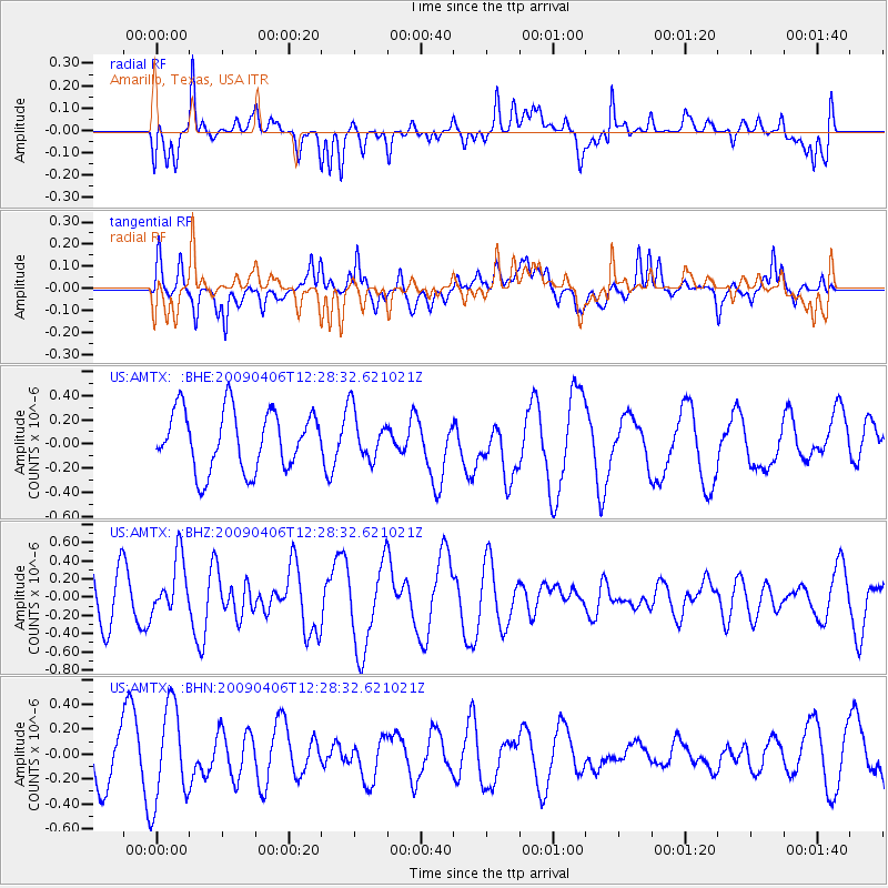
AMTX Amarillo, Texas, USA - Earthquake Result Viewer
*The percent match for this event was below the threshold and hence no stack was calculated.
| Earthquake location: |
Tonga Islands Region |
| Earthquake latitude/longitude: |
-22.4/-174.9 |
| Earthquake time(UTC): |
2009/04/06 (096) 12:16:08 GMT |
| Earthquake Depth: |
35 km |
| Earthquake Magnitude: |
5.5 MS, 5.4 MB |
| Earthquake Catalog/Contributor: |
WHDF/NEIC |
|
| Network: |
US United States National Seismic Network |
| Station: |
AMTX Amarillo, Texas, USA |
| Lat/Lon: |
34.53 N/101.41 W |
| Elevation: |
1010 m |
|
| Distance: |
89.8 deg |
| Az: |
52.347 deg |
| Baz: |
242.57 deg |
| Ray Param: |
$rayparam |
*The percent match for this event was below the threshold and hence was not used in the summary stack. |
|
| Radial Match: |
47.536358 % |
| Radial Bump: |
400 |
| Transverse Match: |
38.93918 % |
| Transverse Bump: |
400 |
| SOD ConfigId: |
2658 |
| Insert Time: |
2010-03-05 03:04:25.902 +0000 |
| GWidth: |
2.5 |
| Max Bumps: |
400 |
| Tol: |
0.001 |
|
Signal To Noise
| Channel | StoN | STA | LTA |
| US:AMTX: :BHZ:20090406T12:28:32.621021Z | 1.0374274 | 3.1718574E-7 | 3.057426E-7 |
| US:AMTX: :BHN:20090406T12:28:32.621021Z | 1.2564844 | 3.9394808E-7 | 3.1353204E-7 |
| US:AMTX: :BHE:20090406T12:28:32.621021Z | 0.7856175 | 1.9155163E-7 | 2.4382302E-7 |
| Arrivals |
| Ps | |
| PpPs | |
| PsPs/PpSs | |


