You are here: Home > Network List > AZ - ANZA Regional Network Stations List
> Station SMER AZ.SMER > Earthquake Result Viewer
SMER AZ.SMER - Earthquake Result Viewer
*The percent match for this event was below the threshold and hence no stack was calculated.
| Earthquake location: |
South Of Fiji Islands |
| Earthquake latitude/longitude: |
-25.5/179.3 |
| Earthquake time(UTC): |
2016/05/13 (134) 12:57:27 GMT |
| Earthquake Depth: |
506 km |
| Earthquake Magnitude: |
5.6 MWW |
| Earthquake Catalog/Contributor: |
NEIC PDE/NEIC COMCAT |
|
| Network: |
AZ ANZA Regional Network |
| Station: |
SMER AZ.SMER |
| Lat/Lon: |
33.46 N/117.17 W |
| Elevation: |
355 m |
|
| Distance: |
84.1 deg |
| Az: |
48.768 deg |
| Baz: |
234.398 deg |
| Ray Param: |
$rayparam |
*The percent match for this event was below the threshold and hence was not used in the summary stack. |
|
| Radial Match: |
48.853443 % |
| Radial Bump: |
400 |
| Transverse Match: |
46.959835 % |
| Transverse Bump: |
400 |
| SOD ConfigId: |
7422571 |
| Insert Time: |
2019-04-22 13:59:47.166 +0000 |
| GWidth: |
2.5 |
| Max Bumps: |
400 |
| Tol: |
0.001 |
|
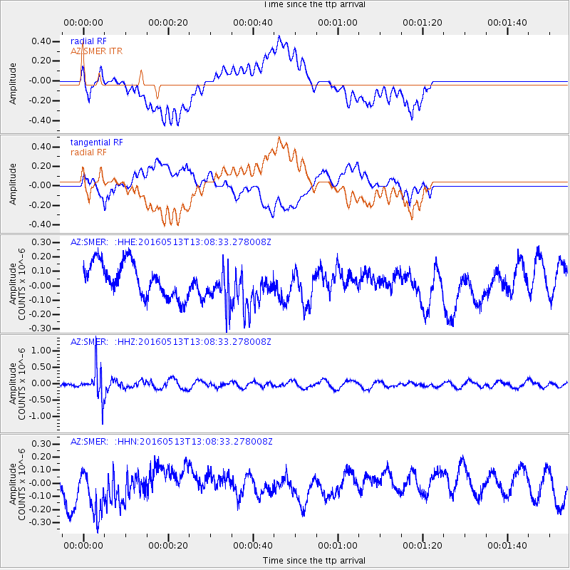
Signal To Noise
| Channel | StoN | STA | LTA |
| AZ:SMER: :HHZ:20160513T13:08:33.278008Z | 4.441965 | 4.4628942E-7 | 1.0047117E-7 |
| AZ:SMER: :HHN:20160513T13:08:33.278008Z | 1.7744501 | 2.3251754E-7 | 1.3103639E-7 |
| AZ:SMER: :HHE:20160513T13:08:33.278008Z | 1.1235859 | 1.3052818E-7 | 1.16171066E-7 |
| Arrivals |
| Ps | |
| PpPs | |
| PsPs/PpSs | |


