You are here: Home > Network List > CI - Caltech Regional Seismic Network Stations List
> Station DGR Domenigoni Reservoir, California, USA > Earthquake Result Viewer
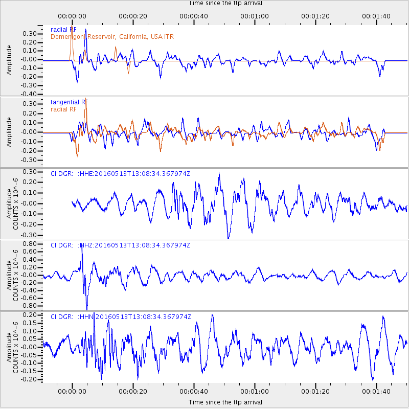
DGR Domenigoni Reservoir, California, USA - Earthquake Result Viewer
*The percent match for this event was below the threshold and hence no stack was calculated.
| Earthquake location: |
South Of Fiji Islands |
| Earthquake latitude/longitude: |
-25.5/179.3 |
| Earthquake time(UTC): |
2016/05/13 (134) 12:57:27 GMT |
| Earthquake Depth: |
506 km |
| Earthquake Magnitude: |
5.6 MWW |
| Earthquake Catalog/Contributor: |
NEIC PDE/NEIC COMCAT |
|
| Network: |
CI Caltech Regional Seismic Network |
| Station: |
DGR Domenigoni Reservoir, California, USA |
| Lat/Lon: |
33.65 N/117.01 W |
| Elevation: |
609 m |
|
| Distance: |
84.3 deg |
| Az: |
48.69 deg |
| Baz: |
234.479 deg |
| Ray Param: |
$rayparam |
*The percent match for this event was below the threshold and hence was not used in the summary stack. |
|
| Radial Match: |
69.93396 % |
| Radial Bump: |
400 |
| Transverse Match: |
59.91156 % |
| Transverse Bump: |
400 |
| SOD ConfigId: |
7422571 |
| Insert Time: |
2019-04-22 14:00:35.218 +0000 |
| GWidth: |
2.5 |
| Max Bumps: |
400 |
| Tol: |
0.001 |
|
Signal To Noise
| Channel | StoN | STA | LTA |
| CI:DGR: :HHZ:20160513T13:08:34.367974Z | 4.4208403 | 3.311084E-7 | 7.489716E-8 |
| CI:DGR: :HHN:20160513T13:08:34.367974Z | 0.4523556 | 3.8292253E-8 | 8.465077E-8 |
| CI:DGR: :HHE:20160513T13:08:34.367974Z | 2.2520099 | 1.0560558E-7 | 4.6893927E-8 |
| Arrivals |
| Ps | |
| PpPs | |
| PsPs/PpSs | |


