You are here: Home > Network List > US - United States National Seismic Network Stations List
> Station AMTX Amarillo, Texas, USA > Earthquake Result Viewer
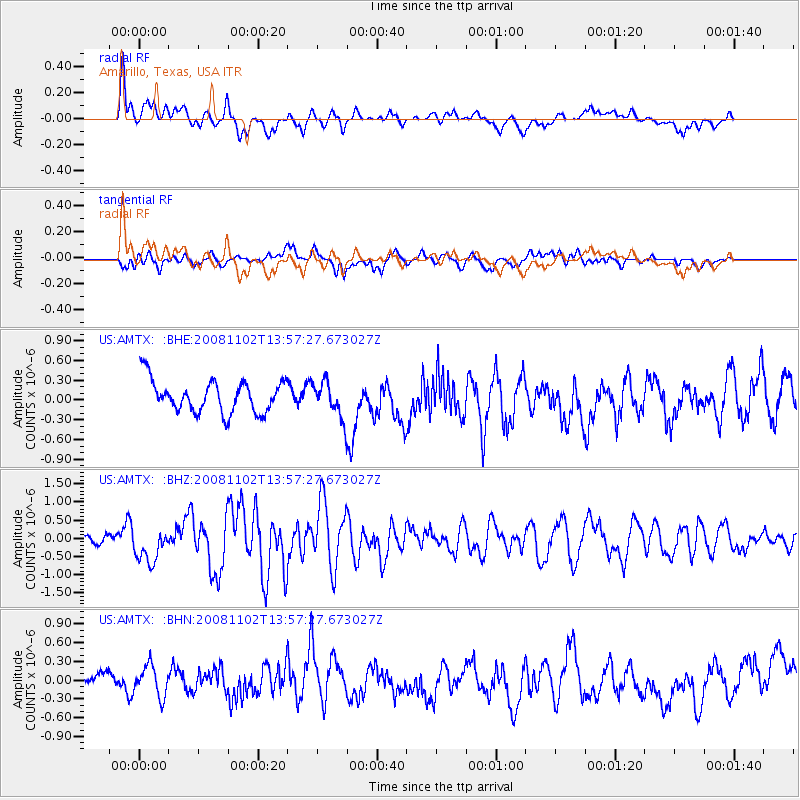
AMTX Amarillo, Texas, USA - Earthquake Result Viewer
*The percent match for this event was below the threshold and hence no stack was calculated.
| Earthquake location: |
Andreanof Islands, Aleutian Is. |
| Earthquake latitude/longitude: |
51.6/-174.4 |
| Earthquake time(UTC): |
2008/11/02 (307) 13:48:42 GMT |
| Earthquake Depth: |
36 km |
| Earthquake Magnitude: |
5.7 MB, 5.8 MS, 6.1 MW, 6.1 MW |
| Earthquake Catalog/Contributor: |
WHDF/NEIC |
|
| Network: |
US United States National Seismic Network |
| Station: |
AMTX Amarillo, Texas, USA |
| Lat/Lon: |
34.53 N/101.41 W |
| Elevation: |
1010 m |
|
| Distance: |
53.7 deg |
| Az: |
78.312 deg |
| Baz: |
312.22 deg |
| Ray Param: |
$rayparam |
*The percent match for this event was below the threshold and hence was not used in the summary stack. |
|
| Radial Match: |
47.727425 % |
| Radial Bump: |
400 |
| Transverse Match: |
44.659603 % |
| Transverse Bump: |
400 |
| SOD ConfigId: |
2658 |
| Insert Time: |
2010-03-05 03:04:44.929 +0000 |
| GWidth: |
2.5 |
| Max Bumps: |
400 |
| Tol: |
0.001 |
|
Signal To Noise
| Channel | StoN | STA | LTA |
| US:AMTX: :BHZ:20081102T13:57:27.673027Z | 2.88475 | 4.77887E-7 | 1.6565977E-7 |
| US:AMTX: :BHN:20081102T13:57:27.673027Z | 1.0450476 | 2.4418975E-7 | 2.3366376E-7 |
| US:AMTX: :BHE:20081102T13:57:27.673027Z | 2.1745477 | 4.235197E-7 | 1.9476221E-7 |
| Arrivals |
| Ps | |
| PpPs | |
| PsPs/PpSs | |


