You are here: Home > Network List > UW - Pacific Northwest Regional Seismic Network Stations List
> Station LEBA Lebam, WA, USA > Earthquake Result Viewer
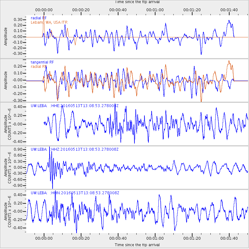
LEBA Lebam, WA, USA - Earthquake Result Viewer
*The percent match for this event was below the threshold and hence no stack was calculated.
| Earthquake location: |
South Of Fiji Islands |
| Earthquake latitude/longitude: |
-25.5/179.3 |
| Earthquake time(UTC): |
2016/05/13 (134) 12:57:27 GMT |
| Earthquake Depth: |
506 km |
| Earthquake Magnitude: |
5.6 MWW |
| Earthquake Catalog/Contributor: |
NEIC PDE/NEIC COMCAT |
|
| Network: |
UW Pacific Northwest Regional Seismic Network |
| Station: |
LEBA Lebam, WA, USA |
| Lat/Lon: |
46.55 N/123.56 W |
| Elevation: |
73 m |
|
| Distance: |
88.3 deg |
| Az: |
35.432 deg |
| Baz: |
229.392 deg |
| Ray Param: |
$rayparam |
*The percent match for this event was below the threshold and hence was not used in the summary stack. |
|
| Radial Match: |
54.184723 % |
| Radial Bump: |
400 |
| Transverse Match: |
48.08362 % |
| Transverse Bump: |
400 |
| SOD ConfigId: |
7422571 |
| Insert Time: |
2019-04-22 14:03:40.153 +0000 |
| GWidth: |
2.5 |
| Max Bumps: |
400 |
| Tol: |
0.001 |
|
Signal To Noise
| Channel | StoN | STA | LTA |
| UW:LEBA: :HHZ:20160513T13:08:53.278008Z | 2.8059645 | 4.0192248E-7 | 1.4323862E-7 |
| UW:LEBA: :HHN:20160513T13:08:53.278008Z | 1.2184271 | 1.7518134E-7 | 1.4377663E-7 |
| UW:LEBA: :HHE:20160513T13:08:53.278008Z | 0.6283541 | 1.1214099E-7 | 1.7846783E-7 |
| Arrivals |
| Ps | |
| PpPs | |
| PsPs/PpSs | |


