You are here: Home > Network List > US - United States National Seismic Network Stations List
> Station AMTX Amarillo, Texas, USA > Earthquake Result Viewer
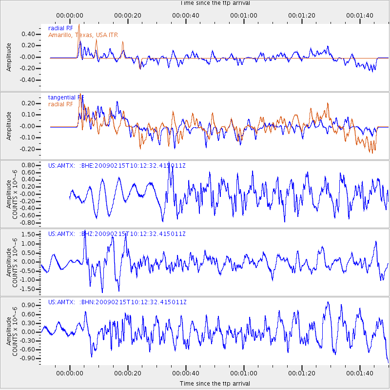
AMTX Amarillo, Texas, USA - Earthquake Result Viewer
*The percent match for this event was below the threshold and hence no stack was calculated.
| Earthquake location: |
Near Coast Of Northern Peru |
| Earthquake latitude/longitude: |
-5.9/-80.9 |
| Earthquake time(UTC): |
2009/02/15 (046) 10:04:49 GMT |
| Earthquake Depth: |
21 km |
| Earthquake Magnitude: |
5.8 MB, 5.7 MS, 6.1 MW, 6.1 MW |
| Earthquake Catalog/Contributor: |
WHDF/NEIC |
|
| Network: |
US United States National Seismic Network |
| Station: |
AMTX Amarillo, Texas, USA |
| Lat/Lon: |
34.53 N/101.41 W |
| Elevation: |
1010 m |
|
| Distance: |
44.6 deg |
| Az: |
335.66 deg |
| Baz: |
150.222 deg |
| Ray Param: |
$rayparam |
*The percent match for this event was below the threshold and hence was not used in the summary stack. |
|
| Radial Match: |
44.763947 % |
| Radial Bump: |
400 |
| Transverse Match: |
49.96869 % |
| Transverse Bump: |
400 |
| SOD ConfigId: |
2658 |
| Insert Time: |
2010-03-05 03:05:06.119 +0000 |
| GWidth: |
2.5 |
| Max Bumps: |
400 |
| Tol: |
0.001 |
|
Signal To Noise
| Channel | StoN | STA | LTA |
| US:AMTX: :BHZ:20090215T10:12:32.415011Z | 0.45244464 | 1.4366131E-7 | 3.175224E-7 |
| US:AMTX: :BHN:20090215T10:12:32.415011Z | 1.024913 | 2.7836566E-7 | 2.7159933E-7 |
| US:AMTX: :BHE:20090215T10:12:32.415011Z | 0.9652517 | 2.57382E-7 | 2.6664756E-7 |
| Arrivals |
| Ps | |
| PpPs | |
| PsPs/PpSs | |


