You are here: Home > Network List > US - United States National Seismic Network Stations List
> Station AMTX Amarillo, Texas, USA > Earthquake Result Viewer
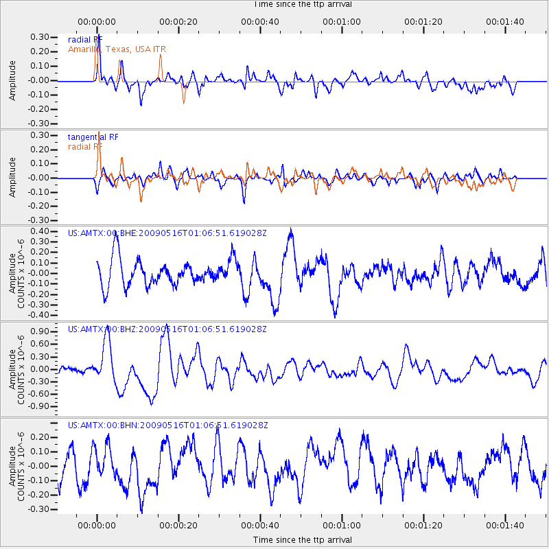
AMTX Amarillo, Texas, USA - Earthquake Result Viewer
*The percent match for this event was below the threshold and hence no stack was calculated.
| Earthquake location: |
Kermadec Islands Region |
| Earthquake latitude/longitude: |
-31.5/-178.8 |
| Earthquake time(UTC): |
2009/05/16 (136) 00:53:52 GMT |
| Earthquake Depth: |
55 km |
| Earthquake Magnitude: |
6.1 MB, 6.5 MW, 6.3 MW |
| Earthquake Catalog/Contributor: |
WHDF/NEIC |
|
| Network: |
US United States National Seismic Network |
| Station: |
AMTX Amarillo, Texas, USA |
| Lat/Lon: |
34.53 N/101.41 W |
| Elevation: |
1010 m |
|
| Distance: |
98.0 deg |
| Az: |
54.452 deg |
| Baz: |
237.313 deg |
| Ray Param: |
$rayparam |
*The percent match for this event was below the threshold and hence was not used in the summary stack. |
|
| Radial Match: |
75.75873 % |
| Radial Bump: |
400 |
| Transverse Match: |
52.85429 % |
| Transverse Bump: |
400 |
| SOD ConfigId: |
2760 |
| Insert Time: |
2010-03-05 03:05:08.942 +0000 |
| GWidth: |
2.5 |
| Max Bumps: |
400 |
| Tol: |
0.001 |
|
Signal To Noise
| Channel | StoN | STA | LTA |
| US:AMTX:00:BHZ:20090516T01:06:51.619028Z | 3.688984 | 5.2743144E-7 | 1.4297471E-7 |
| US:AMTX:00:BHN:20090516T01:06:51.619028Z | 0.9887048 | 1.1123403E-7 | 1.1250479E-7 |
| US:AMTX:00:BHE:20090516T01:06:51.619028Z | 0.9050906 | 1.161824E-7 | 1.283655E-7 |
| Arrivals |
| Ps | |
| PpPs | |
| PsPs/PpSs | |


