You are here: Home > Network List > US - United States National Seismic Network Stations List
> Station AMTX Amarillo, Texas, USA > Earthquake Result Viewer
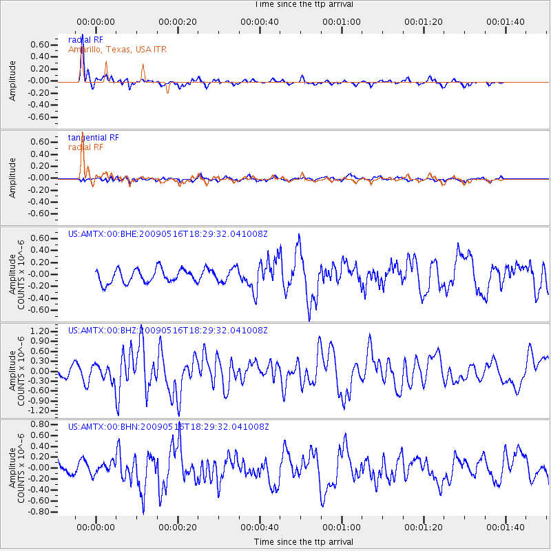
AMTX Amarillo, Texas, USA - Earthquake Result Viewer
*The percent match for this event was below the threshold and hence no stack was calculated.
| Earthquake location: |
Kodiak Island Region, Alaska |
| Earthquake latitude/longitude: |
56.4/-152.4 |
| Earthquake time(UTC): |
2009/05/16 (136) 18:22:25 GMT |
| Earthquake Depth: |
9.7 km |
| Earthquake Magnitude: |
5.9 MS, 5.4 MB, 5.9 MW, 5.8 MW |
| Earthquake Catalog/Contributor: |
WHDF/NEIC |
|
| Network: |
US United States National Seismic Network |
| Station: |
AMTX Amarillo, Texas, USA |
| Lat/Lon: |
34.53 N/101.41 W |
| Elevation: |
1010 m |
|
| Distance: |
40.7 deg |
| Az: |
100.457 deg |
| Baz: |
318.576 deg |
| Ray Param: |
$rayparam |
*The percent match for this event was below the threshold and hence was not used in the summary stack. |
|
| Radial Match: |
88.80363 % |
| Radial Bump: |
313 |
| Transverse Match: |
64.03843 % |
| Transverse Bump: |
400 |
| SOD ConfigId: |
2760 |
| Insert Time: |
2010-03-05 03:05:09.701 +0000 |
| GWidth: |
2.5 |
| Max Bumps: |
400 |
| Tol: |
0.001 |
|
Signal To Noise
| Channel | StoN | STA | LTA |
| US:AMTX:00:BHZ:20090516T18:29:32.041008Z | 2.078739 | 2.3703483E-7 | 1.1402819E-7 |
| US:AMTX:00:BHN:20090516T18:29:32.041008Z | 1.1175448 | 1.054638E-7 | 9.437098E-8 |
| US:AMTX:00:BHE:20090516T18:29:32.041008Z | 1.1592087 | 1.2199635E-7 | 1.0524106E-7 |
| Arrivals |
| Ps | |
| PpPs | |
| PsPs/PpSs | |


