You are here: Home > Network List > US - United States National Seismic Network Stations List
> Station AMTX Amarillo, Texas, USA > Earthquake Result Viewer
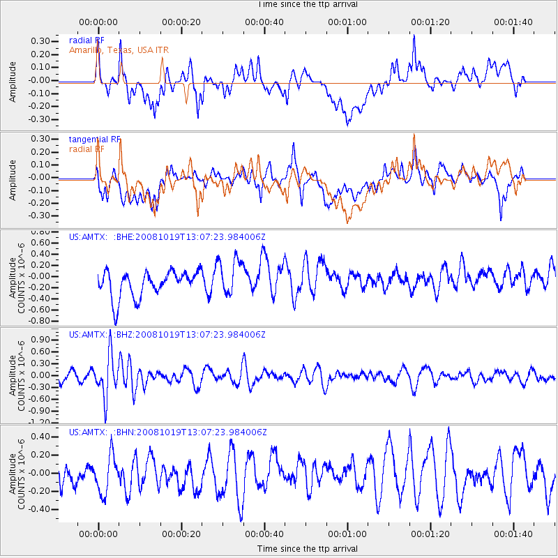
AMTX Amarillo, Texas, USA - Earthquake Result Viewer
*The percent match for this event was below the threshold and hence no stack was calculated.
| Earthquake location: |
Tonga Islands |
| Earthquake latitude/longitude: |
-22.0/-173.7 |
| Earthquake time(UTC): |
2008/10/19 (293) 12:55:05 GMT |
| Earthquake Depth: |
35 km |
| Earthquake Magnitude: |
5.7 MB, 5.3 MS, 5.6 MW, 5.5 MW |
| Earthquake Catalog/Contributor: |
WHDF/NEIC |
|
| Network: |
US United States National Seismic Network |
| Station: |
AMTX Amarillo, Texas, USA |
| Lat/Lon: |
34.53 N/101.41 W |
| Elevation: |
1010 m |
|
| Distance: |
88.7 deg |
| Az: |
51.877 deg |
| Baz: |
242.189 deg |
| Ray Param: |
$rayparam |
*The percent match for this event was below the threshold and hence was not used in the summary stack. |
|
| Radial Match: |
66.683365 % |
| Radial Bump: |
400 |
| Transverse Match: |
41.326878 % |
| Transverse Bump: |
400 |
| SOD ConfigId: |
2556 |
| Insert Time: |
2010-03-05 03:05:12.760 +0000 |
| GWidth: |
2.5 |
| Max Bumps: |
400 |
| Tol: |
0.001 |
|
Signal To Noise
| Channel | StoN | STA | LTA |
| US:AMTX: :BHZ:20081019T13:07:23.984006Z | 3.273119 | 5.3699466E-7 | 1.6406207E-7 |
| US:AMTX: :BHN:20081019T13:07:23.984006Z | 1.5238279 | 2.2642672E-7 | 1.4859074E-7 |
| US:AMTX: :BHE:20081019T13:07:23.984006Z | 1.4105114 | 3.298579E-7 | 2.3385697E-7 |
| Arrivals |
| Ps | |
| PpPs | |
| PsPs/PpSs | |


