You are here: Home > Network List > US - United States National Seismic Network Stations List
> Station AMTX Amarillo, Texas, USA > Earthquake Result Viewer
AMTX Amarillo, Texas, USA - Earthquake Result Viewer
*The percent match for this event was below the threshold and hence no stack was calculated.
| Earthquake location: |
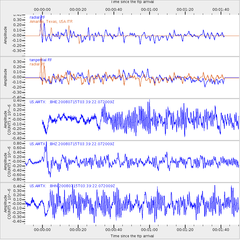
Dodecanese Islands, Greece |
| Earthquake latitude/longitude: |
35.8/27.9 |
| Earthquake time(UTC): |
2008/07/15 (197) 03:26:34 GMT |
| Earthquake Depth: |
52 km |
| Earthquake Magnitude: |
6.5 MB, 6.4 MW, 6.4 MW |
| Earthquake Catalog/Contributor: |
WHDF/NEIC |
|
| Network: |
US United States National Seismic Network |
| Station: |
AMTX Amarillo, Texas, USA |
| Lat/Lon: |
34.53 N/101.41 W |
| Elevation: |
1010 m |
|
| Distance: |
95.5 deg |
| Az: |
320.048 deg |
| Baz: |
39.219 deg |
| Ray Param: |
$rayparam |
*The percent match for this event was below the threshold and hence was not used in the summary stack. |
|
| Radial Match: |
56.972527 % |
| Radial Bump: |
400 |
| Transverse Match: |
42.306396 % |
| Transverse Bump: |
400 |
| SOD ConfigId: |
2504 |
| Insert Time: |
2010-03-05 03:05:13.611 +0000 |
| GWidth: |
2.5 |
| Max Bumps: |
400 |
| Tol: |
0.001 |
|
Signal To Noise
| Channel | StoN | STA | LTA |
| US:AMTX: :BHZ:20080715T03:39:22.072009Z | 4.8039436 | 4.0656775E-7 | 8.4632084E-8 |
| US:AMTX: :BHN:20080715T03:39:22.072009Z | 2.52214 | 1.4933286E-7 | 5.920879E-8 |
| US:AMTX: :BHE:20080715T03:39:22.072009Z | 1.7153434 | 1.4341883E-7 | 8.360941E-8 |
| Arrivals |
| Ps | |
| PpPs | |
| PsPs/PpSs | |


