You are here: Home > Network List > US - United States National Seismic Network Stations List
> Station AMTX Amarillo, Texas, USA > Earthquake Result Viewer
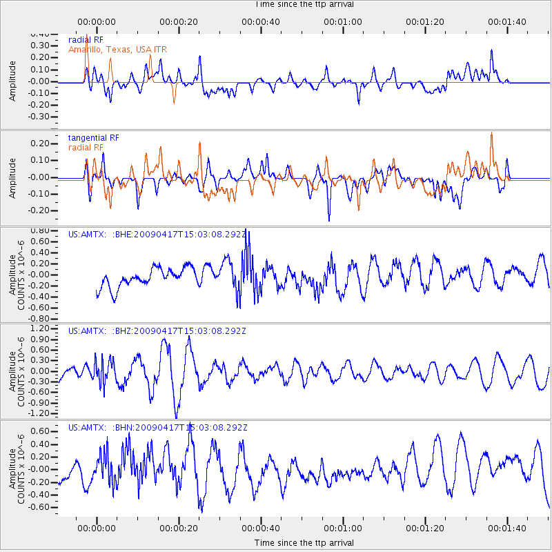
AMTX Amarillo, Texas, USA - Earthquake Result Viewer
*The percent match for this event was below the threshold and hence no stack was calculated.
| Earthquake location: |
Kuril Islands |
| Earthquake latitude/longitude: |
46.2/151.7 |
| Earthquake time(UTC): |
2009/04/17 (107) 14:51:58 GMT |
| Earthquake Depth: |
49 km |
| Earthquake Magnitude: |
5.5 MB, 5.0 MS, 5.7 MW, 5.6 MW |
| Earthquake Catalog/Contributor: |
WHDF/NEIC |
|
| Network: |
US United States National Seismic Network |
| Station: |
AMTX Amarillo, Texas, USA |
| Lat/Lon: |
34.53 N/101.41 W |
| Elevation: |
1010 m |
|
| Distance: |
76.2 deg |
| Az: |
54.448 deg |
| Baz: |
316.776 deg |
| Ray Param: |
$rayparam |
*The percent match for this event was below the threshold and hence was not used in the summary stack. |
|
| Radial Match: |
39.00798 % |
| Radial Bump: |
400 |
| Transverse Match: |
63.811745 % |
| Transverse Bump: |
400 |
| SOD ConfigId: |
2658 |
| Insert Time: |
2010-03-05 03:05:28.710 +0000 |
| GWidth: |
2.5 |
| Max Bumps: |
400 |
| Tol: |
0.001 |
|
Signal To Noise
| Channel | StoN | STA | LTA |
| US:AMTX: :BHZ:20090417T15:03:08.292Z | 1.0965176 | 3.0609309E-7 | 2.7915019E-7 |
| US:AMTX: :BHN:20090417T15:03:08.292Z | 1.0532149 | 2.2097883E-7 | 2.0981363E-7 |
| US:AMTX: :BHE:20090417T15:03:08.292Z | 2.2117534 | 3.621982E-7 | 1.6376066E-7 |
| Arrivals |
| Ps | |
| PpPs | |
| PsPs/PpSs | |


