You are here: Home > Network List > US - United States National Seismic Network Stations List
> Station AMTX Amarillo, Texas, USA > Earthquake Result Viewer
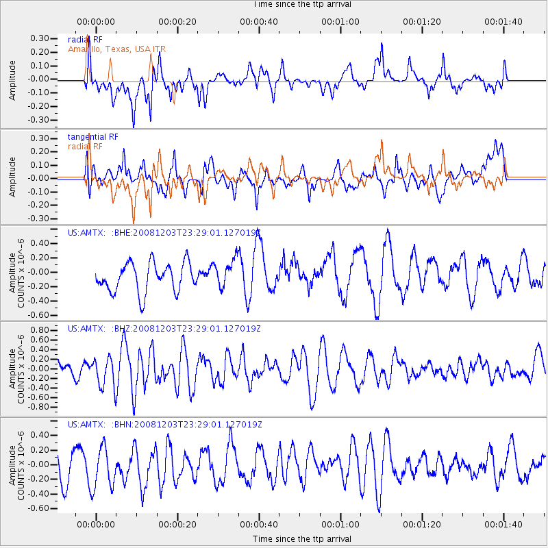
AMTX Amarillo, Texas, USA - Earthquake Result Viewer
*The percent match for this event was below the threshold and hence no stack was calculated.
| Earthquake location: |
Near East Coast Of Honshu, Japan |
| Earthquake latitude/longitude: |
38.6/142.9 |
| Earthquake time(UTC): |
2008/12/03 (338) 23:16:54 GMT |
| Earthquake Depth: |
14 km |
| Earthquake Magnitude: |
5.6 MB, 5.5 MS, 5.8 MW, 5.8 MW |
| Earthquake Catalog/Contributor: |
WHDF/NEIC |
|
| Network: |
US United States National Seismic Network |
| Station: |
AMTX Amarillo, Texas, USA |
| Lat/Lon: |
34.53 N/101.41 W |
| Elevation: |
1010 m |
|
| Distance: |
86.0 deg |
| Az: |
48.216 deg |
| Baz: |
314.944 deg |
| Ray Param: |
$rayparam |
*The percent match for this event was below the threshold and hence was not used in the summary stack. |
|
| Radial Match: |
61.223816 % |
| Radial Bump: |
400 |
| Transverse Match: |
39.961796 % |
| Transverse Bump: |
400 |
| SOD ConfigId: |
2658 |
| Insert Time: |
2010-03-05 03:05:38.847 +0000 |
| GWidth: |
2.5 |
| Max Bumps: |
400 |
| Tol: |
0.001 |
|
Signal To Noise
| Channel | StoN | STA | LTA |
| US:AMTX: :BHZ:20081203T23:29:01.127019Z | 1.7750974 | 3.0452122E-7 | 1.7155183E-7 |
| US:AMTX: :BHN:20081203T23:29:01.127019Z | 1.3266015 | 2.865983E-7 | 2.1603945E-7 |
| US:AMTX: :BHE:20081203T23:29:01.127019Z | 1.173713 | 2.3537713E-7 | 2.0054061E-7 |
| Arrivals |
| Ps | |
| PpPs | |
| PsPs/PpSs | |


