You are here: Home > Network List > US - United States National Seismic Network Stations List
> Station AMTX Amarillo, Texas, USA > Earthquake Result Viewer
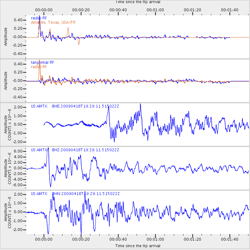
AMTX Amarillo, Texas, USA - Earthquake Result Viewer
*The percent match for this event was below the threshold and hence no stack was calculated.
| Earthquake location: |
Kuril Islands |
| Earthquake latitude/longitude: |
46.0/151.4 |
| Earthquake time(UTC): |
2009/04/18 (108) 19:17:58 GMT |
| Earthquake Depth: |
35 km |
| Earthquake Magnitude: |
6.3 MB, 6.3 MS, 6.6 MW, 6.4 MW |
| Earthquake Catalog/Contributor: |
WHDF/NEIC |
|
| Network: |
US United States National Seismic Network |
| Station: |
AMTX Amarillo, Texas, USA |
| Lat/Lon: |
34.53 N/101.41 W |
| Elevation: |
1010 m |
|
| Distance: |
76.4 deg |
| Az: |
54.246 deg |
| Baz: |
316.764 deg |
| Ray Param: |
$rayparam |
*The percent match for this event was below the threshold and hence was not used in the summary stack. |
|
| Radial Match: |
96.16354 % |
| Radial Bump: |
337 |
| Transverse Match: |
80.021736 % |
| Transverse Bump: |
400 |
| SOD ConfigId: |
2658 |
| Insert Time: |
2010-03-05 03:05:43.803 +0000 |
| GWidth: |
2.5 |
| Max Bumps: |
400 |
| Tol: |
0.001 |
|
Signal To Noise
| Channel | StoN | STA | LTA |
| US:AMTX: :BHZ:20090418T19:29:11.515022Z | 17.637985 | 3.892335E-6 | 2.2067913E-7 |
| US:AMTX: :BHN:20090418T19:29:11.515022Z | 7.9772124 | 1.0863331E-6 | 1.3617954E-7 |
| US:AMTX: :BHE:20090418T19:29:11.515022Z | 6.4424944 | 9.3199907E-7 | 1.4466433E-7 |
| Arrivals |
| Ps | |
| PpPs | |
| PsPs/PpSs | |


