You are here: Home > Network List > US - United States National Seismic Network Stations List
> Station AMTX Amarillo, Texas, USA > Earthquake Result Viewer
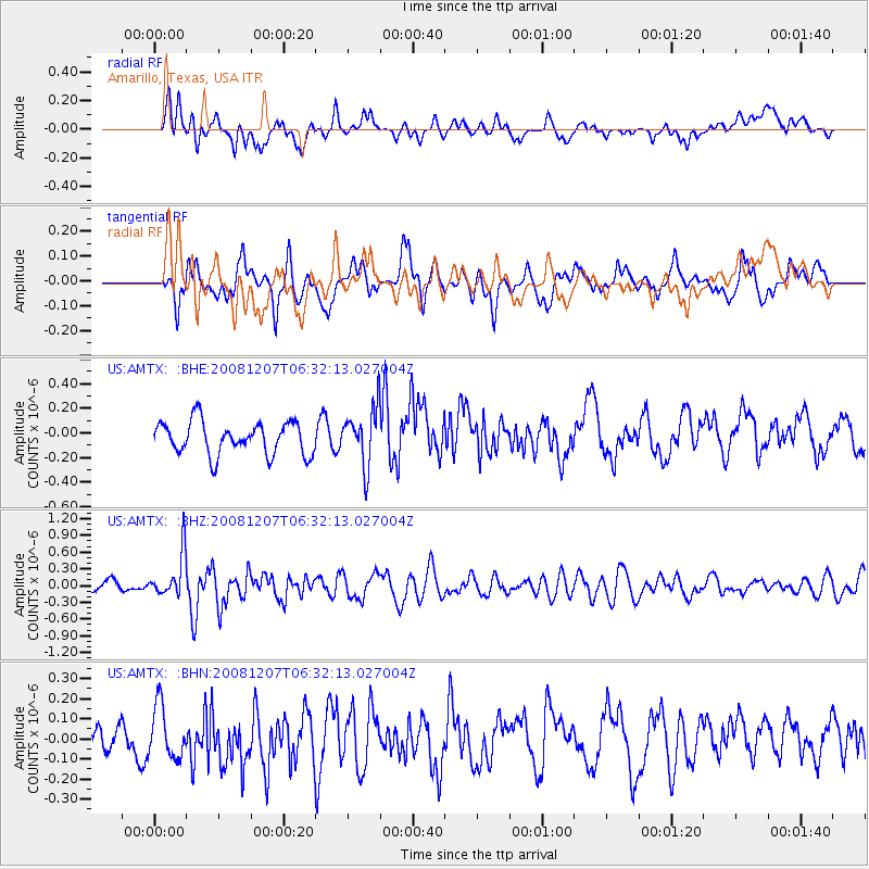
AMTX Amarillo, Texas, USA - Earthquake Result Viewer
*The percent match for this event was below the threshold and hence no stack was calculated.
| Earthquake location: |
Northern Mid-Atlantic Ridge |
| Earthquake latitude/longitude: |
13.4/-44.8 |
| Earthquake time(UTC): |
2008/12/07 (342) 06:23:09 GMT |
| Earthquake Depth: |
10 km |
| Earthquake Magnitude: |
5.6 MB, 5.3 MS, 5.7 MW |
| Earthquake Catalog/Contributor: |
WHDF/NEIC |
|
| Network: |
US United States National Seismic Network |
| Station: |
AMTX Amarillo, Texas, USA |
| Lat/Lon: |
34.53 N/101.41 W |
| Elevation: |
1010 m |
|
| Distance: |
55.1 deg |
| Az: |
302.846 deg |
| Baz: |
97.922 deg |
| Ray Param: |
$rayparam |
*The percent match for this event was below the threshold and hence was not used in the summary stack. |
|
| Radial Match: |
48.515507 % |
| Radial Bump: |
400 |
| Transverse Match: |
57.27464 % |
| Transverse Bump: |
400 |
| SOD ConfigId: |
2658 |
| Insert Time: |
2010-03-05 03:05:47.899 +0000 |
| GWidth: |
2.5 |
| Max Bumps: |
400 |
| Tol: |
0.001 |
|
Signal To Noise
| Channel | StoN | STA | LTA |
| US:AMTX: :BHZ:20081207T06:32:13.027004Z | 2.9854455 | 3.845294E-7 | 1.2880135E-7 |
| US:AMTX: :BHN:20081207T06:32:13.027004Z | 1.3709368 | 1.3269673E-7 | 9.6792746E-8 |
| US:AMTX: :BHE:20081207T06:32:13.027004Z | 1.2928895 | 1.6450463E-7 | 1.2723795E-7 |
| Arrivals |
| Ps | |
| PpPs | |
| PsPs/PpSs | |


