You are here: Home > Network List > US - United States National Seismic Network Stations List
> Station AMTX Amarillo, Texas, USA > Earthquake Result Viewer
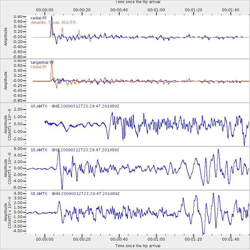
AMTX Amarillo, Texas, USA - Earthquake Result Viewer
*The percent match for this event was below the threshold and hence no stack was calculated.
| Earthquake location: |
South Of Panama |
| Earthquake latitude/longitude: |
5.7/-82.8 |
| Earthquake time(UTC): |
2009/03/12 (071) 23:23:34 GMT |
| Earthquake Depth: |
9.0 km |
| Earthquake Magnitude: |
6.1 MB, 5.9 MS, 6.3 MW, 6.2 MW |
| Earthquake Catalog/Contributor: |
WHDF/NEIC |
|
| Network: |
US United States National Seismic Network |
| Station: |
AMTX Amarillo, Texas, USA |
| Lat/Lon: |
34.53 N/101.41 W |
| Elevation: |
1010 m |
|
| Distance: |
33.5 deg |
| Az: |
331.425 deg |
| Baz: |
144.793 deg |
| Ray Param: |
$rayparam |
*The percent match for this event was below the threshold and hence was not used in the summary stack. |
|
| Radial Match: |
85.84189 % |
| Radial Bump: |
371 |
| Transverse Match: |
57.85039 % |
| Transverse Bump: |
400 |
| SOD ConfigId: |
2658 |
| Insert Time: |
2010-03-05 03:05:52.928 +0000 |
| GWidth: |
2.5 |
| Max Bumps: |
400 |
| Tol: |
0.001 |
|
Signal To Noise
| Channel | StoN | STA | LTA |
| US:AMTX: :BHZ:20090312T23:29:47.201989Z | 1.5024446 | 2.3615978E-7 | 1.5718368E-7 |
| US:AMTX: :BHN:20090312T23:29:47.201989Z | 0.39296886 | 6.312601E-8 | 1.606387E-7 |
| US:AMTX: :BHE:20090312T23:29:47.201989Z | 0.6053114 | 1.7835109E-7 | 2.9464354E-7 |
| Arrivals |
| Ps | |
| PpPs | |
| PsPs/PpSs | |


