You are here: Home > Network List > US - United States National Seismic Network Stations List
> Station AMTX Amarillo, Texas, USA > Earthquake Result Viewer
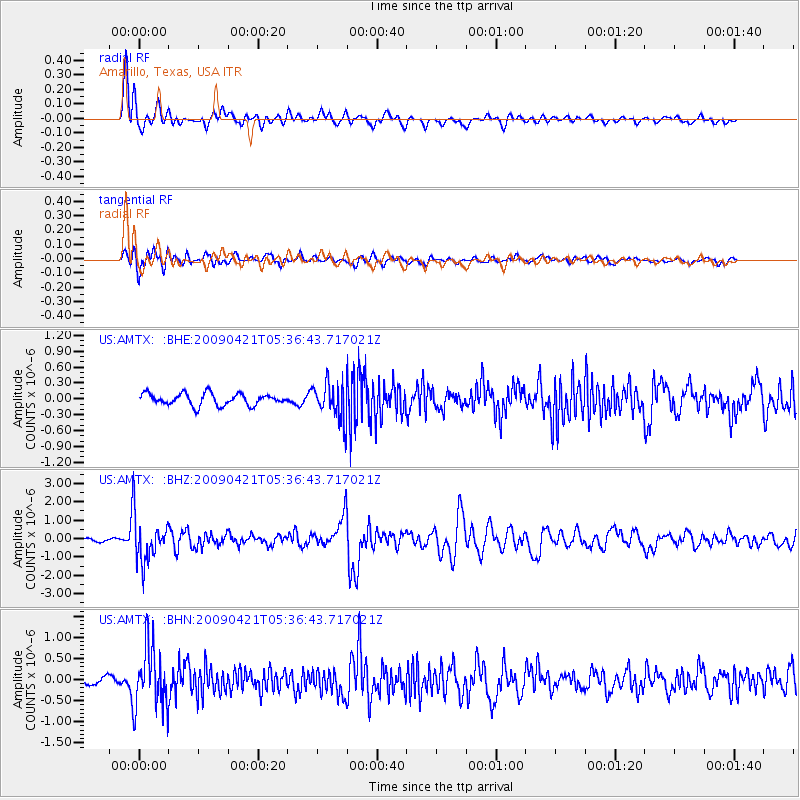
AMTX Amarillo, Texas, USA - Earthquake Result Viewer
*The percent match for this event was below the threshold and hence no stack was calculated.
| Earthquake location: |
Kuril Islands |
| Earthquake latitude/longitude: |
50.8/155.0 |
| Earthquake time(UTC): |
2009/04/21 (111) 05:26:11 GMT |
| Earthquake Depth: |
152 km |
| Earthquake Magnitude: |
6.0 MB, 6.2 MW, 6.2 MW |
| Earthquake Catalog/Contributor: |
WHDF/NEIC |
|
| Network: |
US United States National Seismic Network |
| Station: |
AMTX Amarillo, Texas, USA |
| Lat/Lon: |
34.53 N/101.41 W |
| Elevation: |
1010 m |
|
| Distance: |
71.7 deg |
| Az: |
57.679 deg |
| Baz: |
319.527 deg |
| Ray Param: |
$rayparam |
*The percent match for this event was below the threshold and hence was not used in the summary stack. |
|
| Radial Match: |
78.1741 % |
| Radial Bump: |
400 |
| Transverse Match: |
68.40816 % |
| Transverse Bump: |
400 |
| SOD ConfigId: |
2658 |
| Insert Time: |
2010-03-05 03:05:56.093 +0000 |
| GWidth: |
2.5 |
| Max Bumps: |
400 |
| Tol: |
0.001 |
|
Signal To Noise
| Channel | StoN | STA | LTA |
| US:AMTX: :BHZ:20090421T05:36:43.717021Z | 10.261768 | 1.1528039E-6 | 1.1233969E-7 |
| US:AMTX: :BHN:20090421T05:36:43.717021Z | 7.3296986 | 7.297385E-7 | 9.955914E-8 |
| US:AMTX: :BHE:20090421T05:36:43.717021Z | 4.645952 | 4.9772285E-7 | 1.0713043E-7 |
| Arrivals |
| Ps | |
| PpPs | |
| PsPs/PpSs | |


